IMAGES TAKEN NEAR TO
St. Olafs Grove, GRIMSBY, DN32 0HA
Introduction
This page details the photographs taken nearby to St. Olafs Grove, DN32 0HA by members of the Geograph project.
The Geograph project started in 2005 with the aim of publishing, organising and preserving representative images for every square kilometre of Great Britain, Ireland and the Isle of Man.

There are currently over 7.5m images from over14,400 individuals and you can help contribute to the project by visiting https://www.geograph.org.uk
Image Map (Loading...)


Getting Data...Please wait
Leaflet Map data © OpenStreetMap
Images are licensed for reuse under creativecommons.org/licenses/by-sa/2.0
Notes
- Clicking on the map will re-center to the selected point.
- The higher the marker number, the further away the image location is from the centre of the postcode.
Image Listing (92 Images Found)
Images are licensed for reuse under creativecommons.org/licenses/by-sa/2.0
Image
Details
Distance
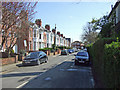
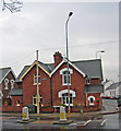
2
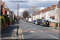
Ainslie Street, Grimsby
Photo taken near the junction with Doughty Road. The building in the park on the left is a scout hut.
Image: © David Wright
Taken: 23 Apr 2008
0.07 miles
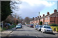
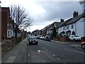
4
Ainslie Street, Grimsby
Photo taken from the corner of Park Drive looking across Welholme Road.
Image: © David Wright
Taken: 25 Feb 2008
0.08 miles
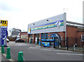
8
Abbey Drive West
Photo taken from Abbey Road.
Image: © David Wright
Taken: 14 Apr 2008
0.10 miles
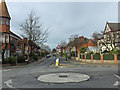
9
The Corner of Doughty Road and Ainslie Street
Note the unusual concrete telephone pole.
Image: © David Wright
Taken: 23 Apr 2008
0.10 miles
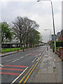
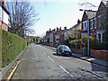
10
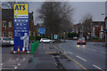
Abbey Road, Grimsby
Looking towards the junction with Wellowgate on a miserable afternoon.
Image: © Stephen McKay
Taken: 10 Dec 2012
0.11 miles