IMAGES TAKEN NEAR TO
Fairview Court, DONCASTER, DN3 1RU
Introduction
This page details the photographs taken nearby to Fairview Court, DN3 1RU by members of the Geograph project.
The Geograph project started in 2005 with the aim of publishing, organising and preserving representative images for every square kilometre of Great Britain, Ireland and the Isle of Man.

There are currently over 7.5m images from over14,400 individuals and you can help contribute to the project by visiting https://www.geograph.org.uk
Image Map
Images are licensed for reuse under creativecommons.org/licenses/by-sa/2.0
Notes
- Clicking on the map will re-center to the selected point.
- The higher the marker number, the further away the image location is from the centre of the postcode.
Image Listing (15 Images Found)
Images are licensed for reuse under creativecommons.org/licenses/by-sa/2.0
Image
Details
Distance
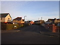
7
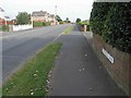
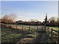
The start of Hatfield Lane Barnby Dun
The lane starts here metalled through housing estates before turning into a track and crossing the railway on its way to Dunsville.
Image: © Steve Fareham
Taken: 9 Sep 2012
0.17 miles
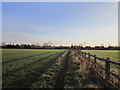
8
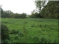
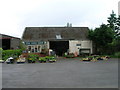
Footpath and Willow
This footpath joins Barnby Dun with Kirk Sandall.
Image: © Michael Patterson
Taken: 16 Oct 2006
0.17 miles