IMAGES TAKEN NEAR TO
Connaught Drive, DONCASTER, DN3 1PH
Introduction
This page details the photographs taken nearby to Connaught Drive, DN3 1PH by members of the Geograph project.
The Geograph project started in 2005 with the aim of publishing, organising and preserving representative images for every square kilometre of Great Britain, Ireland and the Isle of Man.

There are currently over 7.5m images from over14,400 individuals and you can help contribute to the project by visiting https://www.geograph.org.uk
Image Map
Images are licensed for reuse under creativecommons.org/licenses/by-sa/2.0
Notes
- Clicking on the map will re-center to the selected point.
- The higher the marker number, the further away the image location is from the centre of the postcode.
Image Listing (11 Images Found)
Images are licensed for reuse under creativecommons.org/licenses/by-sa/2.0
Image
Details
Distance
4
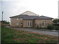
Kirk Sandall and Edenthorpe Church Hall
Kirk Sandall parish church is on the banks of the River Don some distance to the west and away from the main centre of population. The church hall is adjacent to a local shopping centre.
Image: © Jonathan Thacker
Taken: 6 Aug 2011
0.16 miles
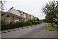
6
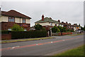
Queen Mary Crescent at Graham Road, Kirk Sandall
Image: © Ian S
Taken: 6 Jun 2018
0.18 miles
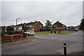
9
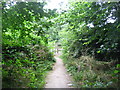
Gateway from Brecks Plantation
Leaving the woods.
Image: © steven ruffles
Taken: 16 Jul 2014
0.22 miles