IMAGES TAKEN NEAR TO
Sutton Road, DONCASTER, DN3 1NY
Introduction
This page details the photographs taken nearby to Sutton Road, DN3 1NY by members of the Geograph project.
The Geograph project started in 2005 with the aim of publishing, organising and preserving representative images for every square kilometre of Great Britain, Ireland and the Isle of Man.

There are currently over 7.5m images from over14,400 individuals and you can help contribute to the project by visiting https://www.geograph.org.uk
Image Map
Images are licensed for reuse under creativecommons.org/licenses/by-sa/2.0
Notes
- Clicking on the map will re-center to the selected point.
- The higher the marker number, the further away the image location is from the centre of the postcode.
Image Listing (6 Images Found)
Images are licensed for reuse under creativecommons.org/licenses/by-sa/2.0
Image
Details
Distance
1
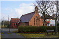
St Thomas of Canterbury
Eccleston Road, Kirk Sandall.
Image: © Ian S
Taken: 22 Feb 2018
0.11 miles
3
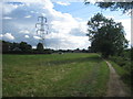
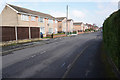
Footpath to Kirk Sandall
From Armthorpe Lane.
Image: © Jonathan Thacker
Taken: 7 Aug 2012
0.21 miles
4
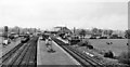
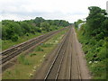
Barnby Dun Station
View SW, towards Doncaster. This station on the important line from Doncaster to Hull and to Grimsby and Cleethorpes was too far from the village, so was closed on 4/9/67, but replaced by the present Kirk Sandall station nearer Doncaster, opened on 13/5/91.
Image: © Ben Brooksbank
Taken: 23 Apr 1961
0.21 miles