IMAGES TAKEN NEAR TO
Meadowfield Road, DONCASTER, DN3 1LN
Introduction
This page details the photographs taken nearby to Meadowfield Road, DN3 1LN by members of the Geograph project.
The Geograph project started in 2005 with the aim of publishing, organising and preserving representative images for every square kilometre of Great Britain, Ireland and the Isle of Man.

There are currently over 7.5m images from over14,400 individuals and you can help contribute to the project by visiting https://www.geograph.org.uk
Image Map
Images are licensed for reuse under creativecommons.org/licenses/by-sa/2.0
Notes
- Clicking on the map will re-center to the selected point.
- The higher the marker number, the further away the image location is from the centre of the postcode.
Image Listing (11 Images Found)
Images are licensed for reuse under creativecommons.org/licenses/by-sa/2.0
Image
Details
Distance
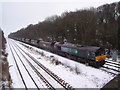
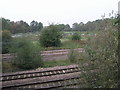
2
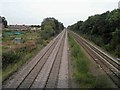
Railway near Kirk Sandall, Doncaster
On the left extensive allotments.
Image: © Steve Fareham
Taken: 9 Sep 2012
0.20 miles
4
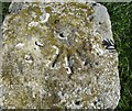
Ordnance Survey Rivet
This OS rivet can be found on an old gatepost to the north of the track.
Image: © Adrian Dust
Taken: 24 May 2016
0.20 miles
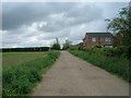
5
Freight train at Barnby Dun
Freight train at Barnby Dun as seen from Armthorpe Lane.
Image: © Martin Speck
Taken: 7 Feb 2012
0.21 miles
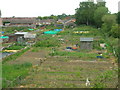
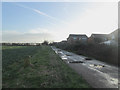
8
Railway and Allotments
The four railway tracks pass by these allotments on the edge of Barnby Dun.
Image: © Michael Patterson
Taken: 16 Oct 2006
0.22 miles