IMAGES TAKEN NEAR TO
Doncaster Road, DONCASTER, DN3 1HE
Introduction
This page details the photographs taken nearby to Doncaster Road, DN3 1HE by members of the Geograph project.
The Geograph project started in 2005 with the aim of publishing, organising and preserving representative images for every square kilometre of Great Britain, Ireland and the Isle of Man.

There are currently over 7.5m images from over14,400 individuals and you can help contribute to the project by visiting https://www.geograph.org.uk
Image Map
Images are licensed for reuse under creativecommons.org/licenses/by-sa/2.0
Notes
- Clicking on the map will re-center to the selected point.
- The higher the marker number, the further away the image location is from the centre of the postcode.
Image Listing (27 Images Found)
Images are licensed for reuse under creativecommons.org/licenses/by-sa/2.0
Image
Details
Distance
1
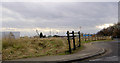
Fence near Kirk Sandall railway station
Image: © Steve Fareham
Taken: 21 Feb 2008
0.02 miles
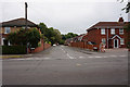
3
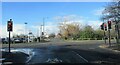
Brecks Lane/ Doncaster Road junction
Looking towards Kirk Sandall railway station
Image: © steven ruffles
Taken: 21 Jan 2021
0.04 miles
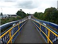
5
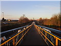
Long Slope
This long sloping walkway carries foot passengers from the island platform of Kirk Sandall railway station.
Image: © Michael Patterson
Taken: 16 Oct 2006
0.06 miles
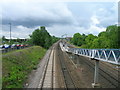
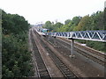
7
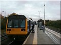
Departing Train at Kirk Sandall Station
Image: © Jonathan Clitheroe
Taken: 24 Oct 2015
0.07 miles