IMAGES TAKEN NEAR TO
Browning Road, DONCASTER, DN3 1AT
Introduction
This page details the photographs taken nearby to Browning Road, DN3 1AT by members of the Geograph project.
The Geograph project started in 2005 with the aim of publishing, organising and preserving representative images for every square kilometre of Great Britain, Ireland and the Isle of Man.

There are currently over 7.5m images from over14,400 individuals and you can help contribute to the project by visiting https://www.geograph.org.uk
Image Map
Images are licensed for reuse under creativecommons.org/licenses/by-sa/2.0
Notes
- Clicking on the map will re-center to the selected point.
- The higher the marker number, the further away the image location is from the centre of the postcode.
Image Listing (20 Images Found)
Images are licensed for reuse under creativecommons.org/licenses/by-sa/2.0
Image
Details
Distance
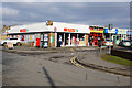
2
Shops at Barnby Dun
Shops on Marlowe Road at Barnby Dun.
Image: © Martin Speck
Taken: 7 Feb 2012
0.09 miles
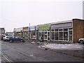
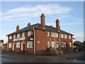
3

Convenience store on Church Road, Barnby Dun
This is at the junction with Marlowe Road where there are other smaller businesses.
Image: © Neil Theasby
Taken: 13 Jan 2022
0.10 miles
4
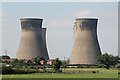
Landscape with cooling towers
The cooling towers of the demolished Thorpe Marsh Power Station dominate housing at Barnby Dun.
Image: © Alan Murray-Rust
Taken: 5 Aug 2007
0.19 miles
6
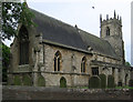
Barnby Dun - Church
For an alternative view, please see Image
Image: © Dave Bevis
Taken: 18 May 2011
0.21 miles
8
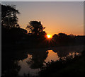
Barnby Dun sunrise
The River Dun Navigation in the foreground.
Image: © Steve Fareham
Taken: 20 Oct 2007
0.22 miles
9
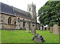
Parish church, Barnby Dun
The church of St Peter & St Paul, Church Rd.
Image: © michael ely
Taken: 30 Aug 2020
0.22 miles
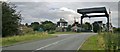
10
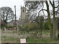
The tower of St Peter's & St Paul's
Seen across a street full of bungalows. The 'Keep Out' sign refers to White House Farm.
Image: © Christine Johnstone
Taken: 4 Apr 2014
0.23 miles