IMAGES TAKEN NEAR TO
Flour Square, GRIMSBY, DN31 3LW
Introduction
This page details the photographs taken nearby to Flour Square, DN31 3LW by members of the Geograph project.
The Geograph project started in 2005 with the aim of publishing, organising and preserving representative images for every square kilometre of Great Britain, Ireland and the Isle of Man.

There are currently over 7.5m images from over14,400 individuals and you can help contribute to the project by visiting https://www.geograph.org.uk
Image Map (Loading...)


Getting Data...Please wait
Leaflet Map data © OpenStreetMap
Images are licensed for reuse under creativecommons.org/licenses/by-sa/2.0
Notes
- Clicking on the map will re-center to the selected point.
- The higher the marker number, the further away the image location is from the centre of the postcode.
Image Listing (91 Images Found)
Images are licensed for reuse under creativecommons.org/licenses/by-sa/2.0
Image
Details
Distance

3
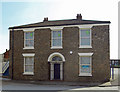
Victorian House, Flour Square, Grimsby
Not in residential use. A sign in the window indicates a seller of Admiralty charts - presumably supplying the nearby marina.
Image: © David Wright
Taken: 10 Apr 2010
0.03 miles
4
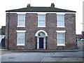
Flour Square, Grimsby
One of the few remaining Georgian Houses left in Grimsby. It is numbered 26, and stands in what is now known as "Flour Square". Personally I think it was in New Dock Street? It is a Grade II Listed Building.
Image: © David Hebb
Taken: 30 Mar 2008
0.05 miles
5
ABP (Associated British Ports) office Grimsby
Situated on Royal Street.
Image: © Steve Fareham
Taken: 10 May 2009
0.05 miles
6
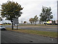
A180 Cleethorpe Road approaching roundabout
Image: © Alan Heardman
Taken: 5 Oct 2009
0.06 miles
7
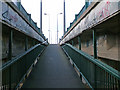
Footbridge over the Railway
Pedestrians cross the Grimsby Docks to Cleethorpes line by this footbridge which also serves as the central reservation of the flyover carrying the A180. See Image for a subterranean view and Image for a surface photo. This is the point at which you emerge on to the top of the flyover travelling West.
Image: © David Wright
Taken: 17 Mar 2007
0.07 miles
9
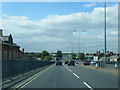
Cleethorpe Road, Grimsby
Photo taken from the corner of Prince Albert Gardens. On the right is the flyover carrying the A180 over the railway.
Image: © David Wright
Taken: 7 Mar 2007
0.07 miles
10
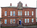
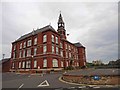
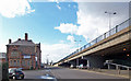
The Old Customs House, Grimsby
Situated on the South side of Cleethorpes Road and overshadowed by the flyover carrying the A180. The Customs House was built in 1874.
Image: © David Wright
Taken: 7 Mar 2007
0.07 miles