IMAGES TAKEN NEAR TO
Henry Street, GRIMSBY, DN31 2JB
Introduction
This page details the photographs taken nearby to Henry Street, DN31 2JB by members of the Geograph project.
The Geograph project started in 2005 with the aim of publishing, organising and preserving representative images for every square kilometre of Great Britain, Ireland and the Isle of Man.

There are currently over 7.5m images from over14,400 individuals and you can help contribute to the project by visiting https://www.geograph.org.uk
Image Map
Images are licensed for reuse under creativecommons.org/licenses/by-sa/2.0
Notes
- Clicking on the map will re-center to the selected point.
- The higher the marker number, the further away the image location is from the centre of the postcode.
Image Listing (4 Images Found)
Images are licensed for reuse under creativecommons.org/licenses/by-sa/2.0
Image
Details
Distance
2
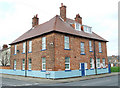
Ayscough Street, Grimsby
The Former St Paul's Vicarage. (A Locally Listed Building)
http://www.flickr.com/photos/riffraff1/2290169027/
Image: © David Hebb
Taken: 16 Jan 2009
0.15 miles
4
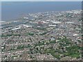
Grimsby Town Centre, railway station and docks: aerial 2021 (2)
Image: © Simon Tomson
Taken: 5 Jun 2021
0.25 miles