IMAGES TAKEN NEAR TO
Chestnut Avenue, DONCASTER, DN2 5SP
Introduction
This page details the photographs taken nearby to Chestnut Avenue, DN2 5SP by members of the Geograph project.
The Geograph project started in 2005 with the aim of publishing, organising and preserving representative images for every square kilometre of Great Britain, Ireland and the Isle of Man.

There are currently over 7.5m images from over14,400 individuals and you can help contribute to the project by visiting https://www.geograph.org.uk
Image Map (Loading...)


Getting Data...Please wait
Leaflet Map data © OpenStreetMap
Images are licensed for reuse under creativecommons.org/licenses/by-sa/2.0
Notes
- Clicking on the map will re-center to the selected point.
- The higher the marker number, the further away the image location is from the centre of the postcode.
Image Listing (24 Images Found)
Images are licensed for reuse under creativecommons.org/licenses/by-sa/2.0
Image
Details
Distance
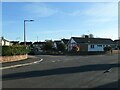
1
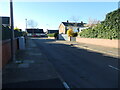
Southern end of Hill Top Crescent, Doncaster
In 1950 this was open land at the northern edge of a sand and gravel pit.
Image: © Christine Johnstone
Taken: 9 Apr 2022
0.11 miles
2
The north side of Ennerdale Road, Doncaster
This part of Wheatley Hills was built in the 1960s.
Image: © Christine Johnstone
Taken: 9 Apr 2022
0.14 miles
3
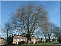
Large tree, Thorne Road, Doncaster
On the amenity grassland at the eastern edge of Wheatley Park.
Image: © Christine Johnstone
Taken: 9 Apr 2022
0.16 miles
4
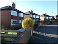
Forsythia in a Masefield Road front garden
Spring has sprung in the Doncaster suburb of Wheatley Hills.
Image: © Christine Johnstone
Taken: 9 Apr 2022
0.16 miles
5
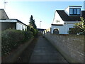
Footpath to Silver Jubilee Close, Doncaster
Running south between two houses on Ennerdale Road.
Image: © Christine Johnstone
Taken: 9 Apr 2022
0.16 miles
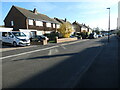
6
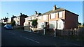
The west side of Masefield Road, Doncaster
The road was laid out by 1938, and these houses built by 1948.
Image: © Christine Johnstone
Taken: 9 Apr 2022
0.16 miles
7
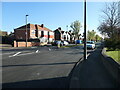
Central Boulevard, Wheatley Hills, Doncaster
The road was laid out between 1929 and 1938, and some of these houses built by 1948.
Image: © Christine Johnstone
Taken: 9 Apr 2022
0.16 miles
8
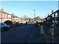
Looking down Masefield Road, Doncaster
There's a reason why this suburb is called Wheatley Hills - the name the area carried when it was farmland.
Image: © Christine Johnstone
Taken: 9 Apr 2022
0.17 miles
9
East side of Edgehill Road, Doncaster
1960s bungalows in Wheatley Hill.
Image: © Christine Johnstone
Taken: 9 Apr 2022
0.19 miles
10
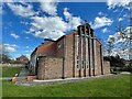
Church of St Aidan
Modern parish church on Central Boulevard
Image: © Graham Hogg
Taken: 27 Mar 2023
0.19 miles