IMAGES TAKEN NEAR TO
The Grove, DONCASTER, DN2 5SB
Introduction
This page details the photographs taken nearby to The Grove, DN2 5SB by members of the Geograph project.
The Geograph project started in 2005 with the aim of publishing, organising and preserving representative images for every square kilometre of Great Britain, Ireland and the Isle of Man.

There are currently over 7.5m images from over14,400 individuals and you can help contribute to the project by visiting https://www.geograph.org.uk
Image Map
Images are licensed for reuse under creativecommons.org/licenses/by-sa/2.0
Notes
- Clicking on the map will re-center to the selected point.
- The higher the marker number, the further away the image location is from the centre of the postcode.
Image Listing (20 Images Found)
Images are licensed for reuse under creativecommons.org/licenses/by-sa/2.0
Image
Details
Distance
1
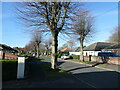
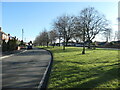
Pollarded trees, The Grove, Doncaster
This road follows the route of a track mapped on the large-scale OS map surveyed in 1849. It became a suburban road lined with bungalows in the 1920s.
Image: © Christine Johnstone
Taken: 9 Apr 2022
0.05 miles
2
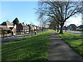
Thorne Road, Doncaster
On the right, the edge of Wheatley Hills, a 1920s and 1930s suburb. On the left, the edge of Wheatley Park, a 1950s suburb. The wide grassy area was created when Wheatley Park was built.
Image: © Christine Johnstone
Taken: 9 Apr 2022
0.08 miles
3
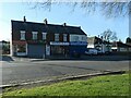
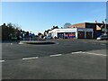
Four shops on Thorne Road, Doncaster
Built in the 1920s, when one of them was a Post Office. Now one sells security services, another DIY tools and the other two are takeaways.
Image: © Christine Johnstone
Taken: 9 Apr 2022
0.09 miles
4

Footpath between Thorne Road and Bristol Grove
This part of the Wheatley Park estate was laid out in the 1940s, and the houses built in the 1950s.
Image: © Christine Johnstone
Taken: 9 Apr 2022
0.11 miles
5
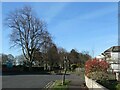
Traffic management, The Grove, Doncaster
Drivers on the western end of The Grove have not been able to turn into Hillcrest Road ever since the suburb was laid out in the 1920s.
Image: © Christine Johnstone
Taken: 9 Apr 2022
0.12 miles
6
Thorne Road, Wheatley Park, Doncaster
The road was rebuilt with a long grassy bank when Wheatley Park was laid out in the 1940s, but most of the houses weren't built and occupied till the 1950s.
Image: © Christine Johnstone
Taken: 9 Apr 2022
0.13 miles
7

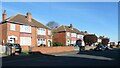
West side of Thornhill Avenue, Doncaster
The road was laid out between 1929 and 1938. Most of the bungalows were also built by 1938.
Image: © Christine Johnstone
Taken: 9 Apr 2022
0.14 miles
8
Tesco Express, Wheatley Hills, Doncaster
At the western end of Central Boulevard.
Image: © Christine Johnstone
Taken: 9 Apr 2022
0.14 miles
9
The northern end of Sandall Rise, Doncaster
The road was laid out between 1929 and 1938, and the houses built by 1948.
Image: © Christine Johnstone
Taken: 9 Apr 2022
0.15 miles
10
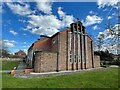
Church of St Aidan
Modern parish church on Central Boulevard
Image: © Graham Hogg
Taken: 27 Mar 2023
0.17 miles