IMAGES TAKEN NEAR TO
Sandall Park Drive, DONCASTER, DN2 5RP
Introduction
This page details the photographs taken nearby to Sandall Park Drive, DN2 5RP by members of the Geograph project.
The Geograph project started in 2005 with the aim of publishing, organising and preserving representative images for every square kilometre of Great Britain, Ireland and the Isle of Man.

There are currently over 7.5m images from over14,400 individuals and you can help contribute to the project by visiting https://www.geograph.org.uk
Image Map (Loading...)


Getting Data...Please wait
Leaflet Map data © OpenStreetMap
Images are licensed for reuse under creativecommons.org/licenses/by-sa/2.0
Notes
- Clicking on the map will re-center to the selected point.
- The higher the marker number, the further away the image location is from the centre of the postcode.
Image Listing (11 Images Found)
Images are licensed for reuse under creativecommons.org/licenses/by-sa/2.0
Image
Details
Distance
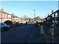
1
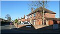
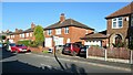
The west side of Boundary Avenue, Doncaster
Catching the early morning sun. The road was laid out in the 1930s. A couple of these houses were built in the 1940s, but most of them were built in the 1950s.
Image: © Christine Johnstone
Taken: 9 Apr 2022
0.17 miles
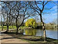
3
Sandall Park
Impressive and attractive park situated in the suburb of Wheatley, north east of Doncaster town centre. The park was previously a brick works and it covers nearly 70 acres.
Image: © Jonathan Clitheroe
Taken: 3 Apr 2017
0.18 miles
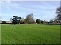
5
The north side of Grove Vale, Doncaster
The road was laid out by 1938, and these houses built by 1948.
Image: © Christine Johnstone
Taken: 9 Apr 2022
0.20 miles
6
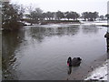
Black swan at Sandall Park
A black swan on the boating lake at Sandall Park.
Image: © Martin Speck
Taken: 7 Feb 2012
0.20 miles
7
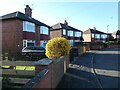
Forsythia in a Masefield Road front garden
Spring has sprung in the Doncaster suburb of Wheatley Hills.
Image: © Christine Johnstone
Taken: 9 Apr 2022
0.21 miles
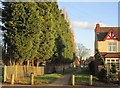
8
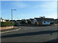
East side of Edgehill Road, Doncaster
1960s bungalows in Wheatley Hill.
Image: © Christine Johnstone
Taken: 9 Apr 2022
0.21 miles
9
Looking down Masefield Road, Doncaster
There's a reason why this suburb is called Wheatley Hills - the name the area carried when it was farmland.
Image: © Christine Johnstone
Taken: 9 Apr 2022
0.21 miles
10
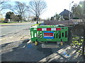
Installing fibre optic cables on Thorne Road
With the promise of faster internet speeds for this area of Doncaster.
Image: © Christine Johnstone
Taken: 9 Apr 2022
0.21 miles