IMAGES TAKEN NEAR TO
Armthorpe Road, DONCASTER, DN2 5QD
Introduction
This page details the photographs taken nearby to Armthorpe Road, DN2 5QD by members of the Geograph project.
The Geograph project started in 2005 with the aim of publishing, organising and preserving representative images for every square kilometre of Great Britain, Ireland and the Isle of Man.

There are currently over 7.5m images from over14,400 individuals and you can help contribute to the project by visiting https://www.geograph.org.uk
Image Map (Loading...)


Getting Data...Please wait
Leaflet Map data © OpenStreetMap
Images are licensed for reuse under creativecommons.org/licenses/by-sa/2.0
Notes
- Clicking on the map will re-center to the selected point.
- The higher the marker number, the further away the image location is from the centre of the postcode.
Image Listing (15 Images Found)
Images are licensed for reuse under creativecommons.org/licenses/by-sa/2.0
Image
Details
Distance
1
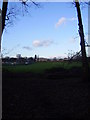
Water tower and Danum School
Taken from the edge of Sandall Beat Wood.
Image: © steven ruffles
Taken: 29 Jan 2010
0.04 miles
3
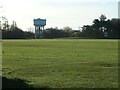
Armthorpe water tower, from the north-west
Built between 1904 and 1929 for Doncaster Corporation's Water Works.
Image: © Christine Johnstone
Taken: 9 Apr 2022
0.11 miles


7
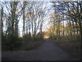
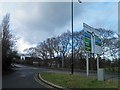
Track leading out of Sandall Beat Wood
Image: © Jonathan Thacker
Taken: 11 Jan 2014
0.19 miles
9
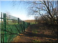
Footpath to Sandall Beat Wood
Passes between a school and an area of allotments.
Image: © Jonathan Thacker
Taken: 11 Jan 2014
0.21 miles
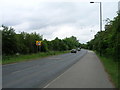
10
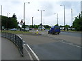
Roadway to the allotments
Sandall Beat Wood can be seen in the far distance.
Image: © Jonathan Thacker
Taken: 11 Jan 2014
0.22 miles