IMAGES TAKEN NEAR TO
Rowan Mount, DONCASTER, DN2 5PG
Introduction
This page details the photographs taken nearby to Rowan Mount, DN2 5PG by members of the Geograph project.
The Geograph project started in 2005 with the aim of publishing, organising and preserving representative images for every square kilometre of Great Britain, Ireland and the Isle of Man.

There are currently over 7.5m images from over14,400 individuals and you can help contribute to the project by visiting https://www.geograph.org.uk
Image Map
Images are licensed for reuse under creativecommons.org/licenses/by-sa/2.0
Notes
- Clicking on the map will re-center to the selected point.
- The higher the marker number, the further away the image location is from the centre of the postcode.
Image Listing (32 Images Found)
Images are licensed for reuse under creativecommons.org/licenses/by-sa/2.0
Image
Details
Distance
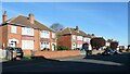
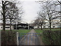
1
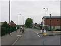
Central Boulevard, Wheatley Hills, Doncaster
The road was laid out between 1929 and 1938, and some of these houses built by 1948.
Image: © Christine Johnstone
Taken: 9 Apr 2022
0.10 miles
2
Oakhill Road, Wheatley Hills, Doncaster
In 1929 the bottom end of this road was part of a sand and gravel quarry. The road was laid out by 1938, but the houses were still being built in 1948.
Image: © Christine Johnstone
Taken: 9 Apr 2022
0.10 miles
3
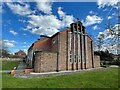
Church of St Aidan
Modern parish church on Central Boulevard
Image: © Graham Hogg
Taken: 27 Mar 2023
0.10 miles
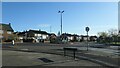
4
The northern end of Sandall Rise, Doncaster
The road was laid out between 1929 and 1938, and the houses built by 1948.
Image: © Christine Johnstone
Taken: 9 Apr 2022
0.12 miles
5
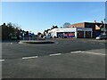
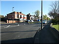
Tesco Express, Wheatley Hills, Doncaster
At the western end of Central Boulevard.
Image: © Christine Johnstone
Taken: 9 Apr 2022
0.13 miles
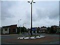
6
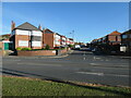
Junction of Armthorpe Road and Sandringham Road
A slightly offset roundabout probably slows down Doncaster's suburban traffic.
Image: © Christine Johnstone
Taken: 9 Apr 2022
0.13 miles
9

West side of Thornhill Avenue, Doncaster
The road was laid out between 1929 and 1938. Most of the bungalows were also built by 1938.
Image: © Christine Johnstone
Taken: 9 Apr 2022
0.15 miles