IMAGES TAKEN NEAR TO
St. Johns Drive, RETFORD, DN22 9NN
Introduction
This page details the photographs taken nearby to St. Johns Drive, DN22 9NN by members of the Geograph project.
The Geograph project started in 2005 with the aim of publishing, organising and preserving representative images for every square kilometre of Great Britain, Ireland and the Isle of Man.

There are currently over 7.5m images from over14,400 individuals and you can help contribute to the project by visiting https://www.geograph.org.uk
Image Map
Images are licensed for reuse under creativecommons.org/licenses/by-sa/2.0
Notes
- Clicking on the map will re-center to the selected point.
- The higher the marker number, the further away the image location is from the centre of the postcode.
Image Listing (49 Images Found)
Images are licensed for reuse under creativecommons.org/licenses/by-sa/2.0
Image
Details
Distance
1
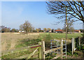
Broad Gores, Clarborough
Bassetlaw District Council-owned 3.44 hectare site. Since the 1970s and the building of housing on Broad Gores, Southview Drive and St John's Drive, the council has owned this land between the northern and southern ends of Broad Gores. It has gone through various stages of full and partial agricultural use, and is currently regarded as wasteland. The parish council has consulted on possible future uses for it such as housing, allotments, and other leisure purposes.
Image: © Paul Harrop
Taken: 11 Mar 2016
0.10 miles
2
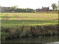
Combed field on the western edge of Clarborough
Seen from the Chesterfield canal towpath soon after dawn.
Image: © Christine Johnstone
Taken: 14 Oct 2011
0.15 miles
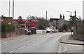
3
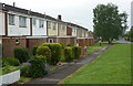
Houses on Smeath Lane
I am not sure whether this is supposed to be Clarborough or Hayton. An online check shows local estate agents refer to both for properties on this road.
Image: © Andrew Hill
Taken: 10 Jun 2010
0.15 miles
5
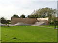
Clarborough and Welham Skatepark
Created in 2012 on the existing recreation ground.
Image: © Alan Murray-Rust
Taken: 5 Oct 2014
0.17 miles
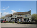
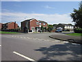
7
Main road with a petrol station
This village still has a shop , post office and Pub.
Image: © roger geach
Taken: 16 Mar 2009
0.17 miles
8

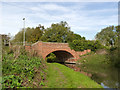
Smeath Lane Bridge
Bridge number 62 on the Chesterfield Canal by the Gate Inn
Image: © Richard Croft
Taken: 12 Aug 2010
0.17 miles
9
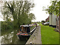
Moorings at The Gate, Clarborough
On the Chesterfield Canal.
Image: © Alan Murray-Rust
Taken: 5 Oct 2014
0.17 miles
10
Clarborough Top Bridge
Chesterfield Canal bridge no.62. Listed Grade II due to remaining substantially unaltered.
Image: © Alan Murray-Rust
Taken: 5 Oct 2014
0.17 miles