IMAGES TAKEN NEAR TO
Main Street, RETFORD, DN22 9NH
Introduction
This page details the photographs taken nearby to Main Street, DN22 9NH by members of the Geograph project.
The Geograph project started in 2005 with the aim of publishing, organising and preserving representative images for every square kilometre of Great Britain, Ireland and the Isle of Man.

There are currently over 7.5m images from over14,400 individuals and you can help contribute to the project by visiting https://www.geograph.org.uk
Image Map (Loading...)


Getting Data...Please wait
Leaflet Map data © OpenStreetMap
Images are licensed for reuse under creativecommons.org/licenses/by-sa/2.0
Notes
- Clicking on the map will re-center to the selected point.
- The higher the marker number, the further away the image location is from the centre of the postcode.
Image Listing (20 Images Found)
Images are licensed for reuse under creativecommons.org/licenses/by-sa/2.0
Image
Details
Distance
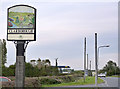
1
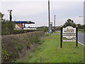
Clarborough village sign
Simply displaying the village church.
Image: © Alan Murray-Rust
Taken: 5 Oct 2014
0.03 miles
3
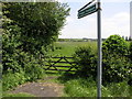
Footpath Shortcut
This footpath cuts across this field and joins up with a bridleway to Little Gringley.
Image: © Michael Patterson
Taken: 2 Jun 2006
0.05 miles
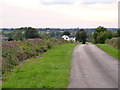
4
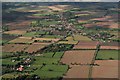
Welham to Clarborough: aerial 2017
Image: © Chris
Taken: 19 Sep 2017
0.06 miles
5
Boundary sign between Clarborough and Welham
The sign displays the same picture on both sides, but with the different village names. It depicts the church, the Chesterfield Canal, and the railway line in general rural scenery. Traditionally Welham has been part of Clarborough parish which is recognised in the current civil parish name. See http://www.geograph.org.uk/photo/4199494 for the other side.
Image: © Alan Murray-Rust
Taken: 5 Oct 2014
0.06 miles
6
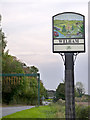
Boundary sign between Clarborough and Welham
The sign displays the same picture on both sides, but with the different village names. It depicts the church, the Chesterfield Canal, and the railway line in general rural scenery. Traditionally Welham has been part of Clarborough parish which is recognised in the current civil parish name. See http://www.geograph.org.uk/photo/4199496 for the other side.
Image: © Alan Murray-Rust
Taken: 5 Oct 2014
0.08 miles
7
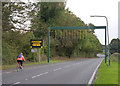
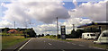
Height restriction warning
The illuminated sign is supposed to be triggered by a vehicle breaking a light beam, but this equipment was currently absent and the sign was continuously lit up.
Image: © Alan Murray-Rust
Taken: 5 Oct 2014
0.09 miles
8
Bone Mill Lane
The white building is Bone Mill Farm. Presumably there was once a mill grinding old bones on the site, which is adjacent to the Chesterfield Canal.
Image: © Alan Murray-Rust
Taken: 5 Oct 2014
0.11 miles
9
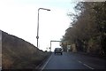
Height warning gantry on A620
East of low bridge
Image: © John Firth
Taken: 19 Jun 2012
0.13 miles
10
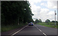
A620 north of Welham
Leaving the northernmost railway overbridge
Image: © John Firth
Taken: 24 Jan 2015
0.15 miles