IMAGES TAKEN NEAR TO
Big Lane, RETFORD, DN22 9LT
Introduction
This page details the photographs taken nearby to Big Lane, DN22 9LT by members of the Geograph project.
The Geograph project started in 2005 with the aim of publishing, organising and preserving representative images for every square kilometre of Great Britain, Ireland and the Isle of Man.

There are currently over 7.5m images from over14,400 individuals and you can help contribute to the project by visiting https://www.geograph.org.uk
Image Map
Images are licensed for reuse under creativecommons.org/licenses/by-sa/2.0
Notes
- Clicking on the map will re-center to the selected point.
- The higher the marker number, the further away the image location is from the centre of the postcode.
Image Listing (13 Images Found)
Images are licensed for reuse under creativecommons.org/licenses/by-sa/2.0
Image
Details
Distance
1
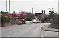
Main road with a petrol station
This village still has a shop , post office and Pub.
Image: © roger geach
Taken: 16 Mar 2009
0.13 miles
2
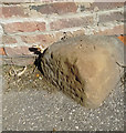
Old Milestone by the A620, Manor Farm, Main Street, Clarborough Parish
Carved stone post by the A620, in parish of CLARBOROUGH (BASSETLAW District), Main Street, opposite Post Office and shop, in tarmac pavement, by brick wall around Manor Farm, on East side of road. Retford stone, erected by the Gainsborough and Retford turnpike trust in the 19th century.
Inscription once read:-
: (East Retford / 3) : : (Gainsborough / 8) :
Milestone Society National ID: NT_RFGN03.
Image: © C Minto
Taken: 28 Jan 2005
0.17 miles
3
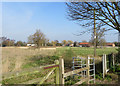
Broad Gores, Clarborough
Bassetlaw District Council-owned 3.44 hectare site. Since the 1970s and the building of housing on Broad Gores, Southview Drive and St John's Drive, the council has owned this land between the northern and southern ends of Broad Gores. It has gone through various stages of full and partial agricultural use, and is currently regarded as wasteland. The parish council has consulted on possible future uses for it such as housing, allotments, and other leisure purposes.
Image: © Paul Harrop
Taken: 11 Mar 2016
0.19 miles
5
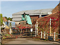
Steam roller at Church Lane Farm
Under the tarpaulin is an Aveling-Barford roller built in 1943.
Image: © Alan Murray-Rust
Taken: 5 Oct 2014
0.20 miles
6
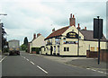
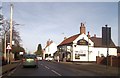
Kings arms Clarborough
Appears to be up for sale. From A620 north
Image: © John Firth
Taken: 12 Jun 2012
0.21 miles
8
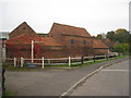
Church Lane Farm, Clarborough
Typical eighteenth century farm buildings on good condition.
Image: © Jonathan Thacker
Taken: 19 Oct 2012
0.21 miles
9
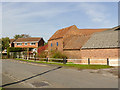
Church Lane, Clarborough
With traditional farm buildings at Church Lane farm.
Image: © Alan Murray-Rust
Taken: 5 Oct 2014
0.21 miles
10
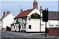
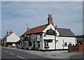
Kings Arms pub
As seen from the main road running through the village.
Image: © roger geach
Taken: 16 Mar 2009
0.22 miles