IMAGES TAKEN NEAR TO
The Avenue, RETFORD, DN22 8DD
Introduction
This page details the photographs taken nearby to The Avenue, DN22 8DD by members of the Geograph project.
The Geograph project started in 2005 with the aim of publishing, organising and preserving representative images for every square kilometre of Great Britain, Ireland and the Isle of Man.

There are currently over 7.5m images from over14,400 individuals and you can help contribute to the project by visiting https://www.geograph.org.uk
Image Map (Loading...)


Getting Data...Please wait
Leaflet Map data © OpenStreetMap
Images are licensed for reuse under creativecommons.org/licenses/by-sa/2.0
Notes
- Clicking on the map will re-center to the selected point.
- The higher the marker number, the further away the image location is from the centre of the postcode.
Image Listing (9 Images Found)
Images are licensed for reuse under creativecommons.org/licenses/by-sa/2.0
Image
Details
Distance
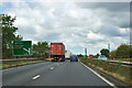
1
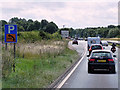
Layby on Southbound A1 near to West Drayton
Image: © David Dixon
Taken: 2 Aug 2015
0.18 miles
3
The A1 Looking North
From the Lay-by in this pic Image
Image: © Stephen Armstrong
Taken: 3 Oct 2009
0.18 miles
4
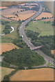
View down the A1 from Gamston Airfield towards West Drawton: aerial 2013
Just airborne from Runway 21 at Gamston Airfield, and looking SE down the A1. The West Drayton turnoff is just beyond the river.
Image: © Chris
Taken: 8 Aug 2013
0.20 miles
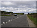
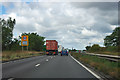
5
A1 northbound
B6387 turn-off 1/2 mile ahead.
Image: © Robin Webster
Taken: 7 Oct 2011
0.21 miles

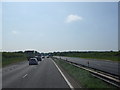
8
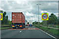
A1 - start of 50 limit
A permanent limit over a stretch of busy and somewhat sinuous road with many side turnings. It lasts for two or three miles.
Image: © Robin Webster
Taken: 7 Oct 2011
0.24 miles
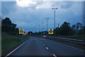
9
A1 - 50 limit 1/4 mile ahead
A rather bendy stretch with a lot of side turnings is ahead.
Image: © Robin Webster
Taken: 7 Oct 2011
0.24 miles