IMAGES TAKEN NEAR TO
Leafield, RETFORD, DN22 7LP
Introduction
This page details the photographs taken nearby to Leafield, DN22 7LP by members of the Geograph project.
The Geograph project started in 2005 with the aim of publishing, organising and preserving representative images for every square kilometre of Great Britain, Ireland and the Isle of Man.

There are currently over 7.5m images from over14,400 individuals and you can help contribute to the project by visiting https://www.geograph.org.uk
Image Map (Loading...)


Getting Data...Please wait
Leaflet Map data © OpenStreetMap
Images are licensed for reuse under creativecommons.org/licenses/by-sa/2.0
Notes
- Clicking on the map will re-center to the selected point.
- The higher the marker number, the further away the image location is from the centre of the postcode.
Image Listing (14 Images Found)
Images are licensed for reuse under creativecommons.org/licenses/by-sa/2.0
Image
Details
Distance
1
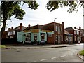
Alpha Pet Foods, Retford
Looking from West Furlong
Image: © Steve Fareham
Taken: 28 Jul 2009
0.15 miles
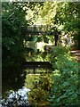
3
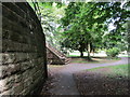
Steps up to the bridge
Cemetery Bridge.
Image: © Jonathan Thacker
Taken: 13 Jun 2014
0.18 miles
4
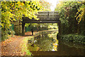
Cemetery bridge
Boys fishing under bridge 54B on the Chesterfield Canal
Image: © Richard Croft
Taken: 19 Oct 2012
0.18 miles
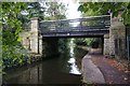
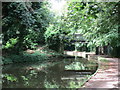
6
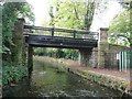
Cemetery Bridge
Bridge 54b on the Chesterfield Canal links two parts of Retford Cemetery.
Image: © Christine Johnstone
Taken: 13 Oct 2011
0.19 miles
7
Chesterfield Canal bridge 54B
A footbridge which connects two parts of Retford Cemetery
Image: © Graham Hogg
Taken: 3 Sep 2012
0.19 miles
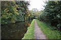
8
Approaching Cemetery Bridge
On the Chesterfield Canal.
Image: © Jonathan Thacker
Taken: 13 Jun 2014
0.19 miles