IMAGES TAKEN NEAR TO
Cricket Field Lane, RETFORD, DN22 7LA
Introduction
This page details the photographs taken nearby to Cricket Field Lane, DN22 7LA by members of the Geograph project.
The Geograph project started in 2005 with the aim of publishing, organising and preserving representative images for every square kilometre of Great Britain, Ireland and the Isle of Man.

There are currently over 7.5m images from over14,400 individuals and you can help contribute to the project by visiting https://www.geograph.org.uk
Image Map
Images are licensed for reuse under creativecommons.org/licenses/by-sa/2.0
Notes
- Clicking on the map will re-center to the selected point.
- The higher the marker number, the further away the image location is from the centre of the postcode.
Image Listing (99 Images Found)
Images are licensed for reuse under creativecommons.org/licenses/by-sa/2.0
Image
Details
Distance
1
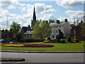
Roundabout at Retford
A busy six exit roundabout west of the town centre. St Michael's Church is in the background.
Image: © Andrew Hill
Taken: 12 May 2010
0.06 miles
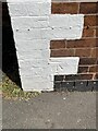
2
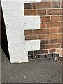
OS Cut Mark - Retford, Number 72 Bridgegate
https://www.bench-marks.org.uk/bm73740
Image: © thejackrustles
Taken: 11 Oct 2021
0.06 miles
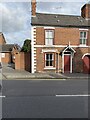
5
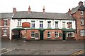
Galway Arms
Inn on Bridgegate, formerly the Great North Road through Retford
Image: © Richard Croft
Taken: 7 Jan 2009
0.08 miles

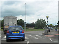
7
Cadet training centre, Retford
The training centre is situated on Hallcroft Road.
Image: © Andrew Hill
Taken: 29 Sep 2010
0.08 miles
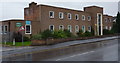
8
Scholarship cottages
Mid 19th century cottages, part of the Trinity Hospital estate. The rent from these cottages is used for the scholarship fund http://www.geograph.org.uk/photo/4700551 (see below). Listed Grade II.
There is a bench mark http://www.geograph.org.uk/photo/4700569 on the near corner.
Image: © Alan Murray-Rust
Taken: 11 Oct 2015
0.08 miles
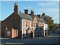
9
Almshouses on Bridgegate
These almshouses were endowed in the will of John Darrell 1621-1665. On the near angle is a cut bench mark. See https://www.geograph.org.uk/photo/7171617 for a close view and https://www.bench-marks.org.uk/bm73740 fir details of the mark.
Image: © Brian Westlake
Taken: 5 May 2022
0.08 miles
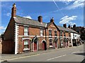
10
Cut Benchmark on Almshouses, Bridgegate
Cut bench mark on the left angle of the row. See https://www.geograph.org.uk/photo/7171615 for a wider view and https://www.bench-marks.org.uk/bm73740 for details of the mark.
Image: © Brian Westlake
Taken: 5 May 2022
0.08 miles