IMAGES TAKEN NEAR TO
Mill Bridge Close, RETFORD, DN22 6FE
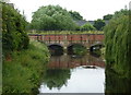
Introduction
This page details the photographs taken nearby to Mill Bridge Close, DN22 6FE by members of the Geograph project.
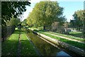
The Geograph project started in 2005 with the aim of publishing, organising and preserving representative images for every square kilometre of Great Britain, Ireland and the Isle of Man.

There are currently over 7.5m images from over14,400 individuals and you can help contribute to the project by visiting https://www.geograph.org.uk
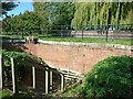
Image Map
Images are licensed for reuse under creativecommons.org/licenses/by-sa/2.0
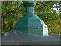
Notes
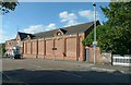
- Clicking on the map will re-center to the selected point.
- The higher the marker number, the further away the image location is from the centre of the postcode.
Image Listing (173 Images Found)
Images are licensed for reuse under creativecommons.org/licenses/by-sa/2.0
Image
Details
Distance
1

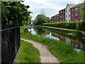
Chesterfield Canal
A narrowboat on the Chesterfield Canal at Retford, with Town Lock in the distance
Image: © Richard Croft
Taken: 12 Aug 2010
0.01 miles
2
River Idle and the canal aqueduct
Looking upstream to the bridge carrying the Chesterfield Canal.
Image: © Andrew Hill
Taken: 12 Jul 2010
0.04 miles
3
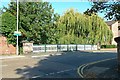
Albert Road Bridge
Opened in 1893 to improve access to the Railway Station
Image: © Alan Murray-Rust
Taken: 11 Oct 2015
0.04 miles
4
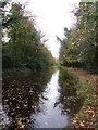
Towpath of the Chesterfield Canal in Retford
At the eastern end of the River Idle Aqueduct.
Image: © Mat Fascione
Taken: 28 May 2016
0.04 miles
5
Chesterfield canal.
A green route through Retford.
Image: © steven ruffles
Taken: 18 Nov 2011
0.04 miles
6
Retford Top Aqueduct
It seems that the watercourse for which this was provided was cut off a long time ago. Even the 1885 OS map shows nothing, but something must have justified the initial expense.
Image: © Alan Murray-Rust
Taken: 11 Oct 2015
0.04 miles
7
Idle Aqueduct
Showing the narrow channel wide enough only for a single boat.
Image: © Alan Murray-Rust
Taken: 11 Oct 2015
0.05 miles
8
Cast iron lamp base, Albert Road Bridge
The lettering shows that it was made at the neighbouring Carr Foundry http://www.geograph.org.uk/photo/4699368 in 1893.
Image: © Alan Murray-Rust
Taken: 11 Oct 2015
0.05 miles
9
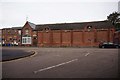
Former Public Baths
This contained a swimming pool and ordinary baths. I hope there are windows on the other side, otherwise it would have been a very dark place.
Image: © Alan Murray-Rust
Taken: 11 Oct 2015
0.05 miles
10
Former Public Baths
On Albert Road, Retford.
Image: © Ian S
Taken: 12 Oct 2019
0.05 miles