IMAGES TAKEN NEAR TO
Ring O Bells, RETFORD, DN22 0NW
Introduction
This page details the photographs taken nearby to Ring O Bells, DN22 0NW by members of the Geograph project.
The Geograph project started in 2005 with the aim of publishing, organising and preserving representative images for every square kilometre of Great Britain, Ireland and the Isle of Man.

There are currently over 7.5m images from over14,400 individuals and you can help contribute to the project by visiting https://www.geograph.org.uk
Image Map (Loading...)


Getting Data...Please wait
Leaflet Map data © OpenStreetMap
Images are licensed for reuse under creativecommons.org/licenses/by-sa/2.0
Notes
- Clicking on the map will re-center to the selected point.
- The higher the marker number, the further away the image location is from the centre of the postcode.
Image Listing (57 Images Found)
Images are licensed for reuse under creativecommons.org/licenses/by-sa/2.0
Image
Details
Distance
1
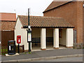
Bus Shelter and postbox, Laneham
The postbox (ref DN22 54) is a standard EIIR lampbox on post. A notice in the shelter states that it was built in the style of a cottage that formerly stood here.
Image: © Alan Murray-Rust
Taken: 3 Sep 2014
0.02 miles
2
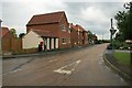
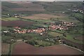
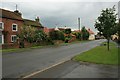
Rampton Road, Laneham
There seem to be several new or renvated houses in the village. The adjoining bus stop also looks new - perhaps provided or updated as part of the development?
Image: © Katy Walters
Taken: 13 Jun 2008
0.03 miles
3
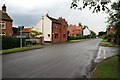
Rampton Road and Main Street, Laneham
At the western end of this largely linear village.
Image: © Katy Walters
Taken: 13 Jun 2008
0.04 miles
4
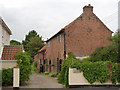
Outbuildings at Endon House
The central portion dates back to the 17th century and once formed a smithy. The nearer and farther sections are 19th century. Listed Grade II.
Image: © Alan Murray-Rust
Taken: 3 Sep 2014
0.04 miles
6
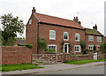
The Croft, Main Street
Late 18th century farmhouse. Listed Grade II, including the wall surrounding the front garden.
Image: © Alan Murray-Rust
Taken: 3 Sep 2014
0.06 miles
7
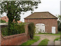
Barn at The Croft, Main Street
Early 19th century, too small to be a threshing barn, but following the same style. Listed Grade II.
Image: © Alan Murray-Rust
Taken: 3 Sep 2014
0.06 miles
8
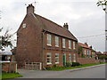
Binge Farmhouse, Main Street
Doubtless a family name rather than any propensity for drinking! Mid-18th century 5-bay farmhouse, Listed Grade II.
Image: © Alan Murray-Rust
Taken: 3 Sep 2014
0.08 miles
9
Main street, Laneham
Looking towards the junction with Dunham Road.
Image: © Katy Walters
Taken: 13 Jun 2008
0.08 miles
10
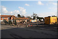
Site of the Butchers Arms
The eventual demise of the Butchers Arms in Laneham http://www.geograph.org.uk/photo/209037 and http://www.geograph.org.uk/photo/849317
Image: © Richard Croft
Taken: 20 Feb 2010
0.08 miles