IMAGES TAKEN NEAR TO
Stokeham, RETFORD, DN22 0JY
Introduction
This page details the photographs taken nearby to DN22 0JY by members of the Geograph project.
The Geograph project started in 2005 with the aim of publishing, organising and preserving representative images for every square kilometre of Great Britain, Ireland and the Isle of Man.

There are currently over 7.5m images from over14,400 individuals and you can help contribute to the project by visiting https://www.geograph.org.uk
Image Map (Loading...)


Getting Data...Please wait
Leaflet Map data © OpenStreetMap
Images are licensed for reuse under creativecommons.org/licenses/by-sa/2.0
Notes
- Clicking on the map will re-center to the selected point.
- The higher the marker number, the further away the image location is from the centre of the postcode.
Image Listing (30 Images Found)
Images are licensed for reuse under creativecommons.org/licenses/by-sa/2.0
Image
Details
Distance
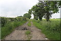
2
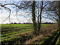
Stokeham seen from Wranglands Lane
Image: © Jonathan Thacker
Taken: 20 Dec 2014
0.09 miles
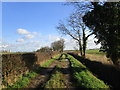
3
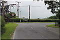
Junction of Drayton Road and Main Street
Retford left, Rampton right.
Image: © J.Hannan-Briggs
Taken: 14 Jun 2014
0.12 miles
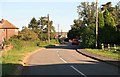
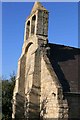
4
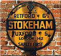
Old circular AA Sign in Stokeham
Old AA Sign in Stokeham, 6 miles southeast of Retford. Stokeham parish.
This is the circular, village name on black band, no Motor Union symbol or name type, dating from 1923, and showing distances Retford 6½ Tuxford 5 London 142. Now missing.
There were five series of AA signs, mostly dating from 1923 and made by Francis & Co / Franco in Deptford, London. The village name and distance to London were usually displayed.
Milestone Society National ID: NT-STOKE
Image: © Milestone Society
Taken: Unknown
0.14 miles
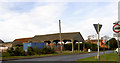
5
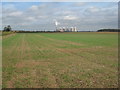
View towards Cottam power station
The Trentside power stations dominate views in this area.
Image: © Jonathan Thacker
Taken: 21 Oct 2011
0.15 miles
7
Smokey (steamy) road Stokeham
A distant West Burton power station creates fumulus clouds.
Image: © Steve Fareham
Taken: 20 Feb 2009
0.17 miles