IMAGES TAKEN NEAR TO
Orchard Lane, RETFORD, DN22 0FD
Introduction
This page details the photographs taken nearby to Orchard Lane, DN22 0FD by members of the Geograph project.
The Geograph project started in 2005 with the aim of publishing, organising and preserving representative images for every square kilometre of Great Britain, Ireland and the Isle of Man.

There are currently over 7.5m images from over14,400 individuals and you can help contribute to the project by visiting https://www.geograph.org.uk
Image Map
Images are licensed for reuse under creativecommons.org/licenses/by-sa/2.0
Notes
- Clicking on the map will re-center to the selected point.
- The higher the marker number, the further away the image location is from the centre of the postcode.
Image Listing (64 Images Found)
Images are licensed for reuse under creativecommons.org/licenses/by-sa/2.0
Image
Details
Distance
1
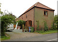
The Granary, White's Farm
Former 19th century cart shed with granary over, now converted for residential use.
The complex of farm buildings at White's Farm was Listed Grade II as a coherent set of 19th farm buildings, but conversion for residential use has effectively destroyed their historic character and all were removed from the Heritage List in 2012.
Image: © Alan Murray-Rust
Taken: 3 Sep 2014
0.03 miles
2
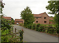
Buildings at White's Farm
The complex of farm buildings at White's Farm was Listed Grade II as a coherent set of 19th farm buildings, but conversion for residential use has effectively destroyed their historic character and all were removed from the Heritage List in 2012.
Image: © Alan Murray-Rust
Taken: 3 Sep 2014
0.03 miles
3
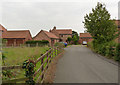
Buildings at White's Farm
The complex of farm buildings at White's Farm was Listed Grade II as a coherent set of 19th farm buildings, but conversion for residential use has effectively destroyed their historic character and all were removed from the Heritage List in 2012.
Image: © Alan Murray-Rust
Taken: 3 Sep 2014
0.03 miles
4
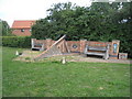
South Leverton Millennium Monument
The seat on the right bears the inscription - , HI TECH, LO TECH, WE MAKE IT WORK.
Image: © Jonathan Thacker
Taken: 29 Jul 2011
0.04 miles
5
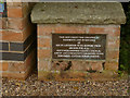
South Leverton Millennium Monument
Dedication plaque. See http://www.geograph.org.uk/photo/4154245 for the complete monument.
Image: © Alan Murray-Rust
Taken: 3 Sep 2014
0.04 miles
6
South Leverton Millennium Monument (detail)
Showing some of the decorative ceramics and the inscription on one of the timber seats. See http://www.geograph.org.uk/photo/4154245
Image: © Alan Murray-Rust
Taken: 3 Sep 2014
0.04 miles
7
South Leverton Millennium Monument (detail)
Ceramic faces in the back wall of the monument, and the message "Smile, be happy". See http://www.geograph.org.uk/photo/4154245 for the monument itself.
Image: © Alan Murray-Rust
Taken: 3 Sep 2014
0.04 miles
8
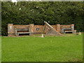
South Leverton Millennium Monument
An overall view of the monument. There is a second M hidden by the central ramp to complete the date MM.
Image: © Alan Murray-Rust
Taken: 3 Sep 2014
0.04 miles
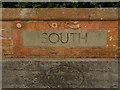
9
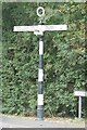
Old Direction Sign - Signpost by Church Street, South Leverton parish
Annulus finial - 3 arms; Notts CC halo by the UC road, in parish of South Leverton (Bassetlaw District), Church Street junction with Retford Road, on pavement, East side of road.
Surveyed
Milestone Society National ID: NT_SK7881
Image: © Milestone Society
Taken: Unknown
0.05 miles
