IMAGES TAKEN NEAR TO
Habblesthorpe Close, RETFORD, DN22 0BD
Introduction
This page details the photographs taken nearby to Habblesthorpe Close, DN22 0BD by members of the Geograph project.
The Geograph project started in 2005 with the aim of publishing, organising and preserving representative images for every square kilometre of Great Britain, Ireland and the Isle of Man.

There are currently over 7.5m images from over14,400 individuals and you can help contribute to the project by visiting https://www.geograph.org.uk
Image Map
Images are licensed for reuse under creativecommons.org/licenses/by-sa/2.0
Notes
- Clicking on the map will re-center to the selected point.
- The higher the marker number, the further away the image location is from the centre of the postcode.
Image Listing (33 Images Found)
Images are licensed for reuse under creativecommons.org/licenses/by-sa/2.0
Image
Details
Distance
1
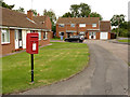
Habblesthorpe Road postbox ref DN22 49
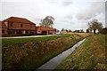
Standard EIIR lampbox on post, on Habblesthorpe Close, a local authority development at the east end of the village.
Image: © Alan Murray-Rust
Taken: 3 Sep 2014
0.00 miles
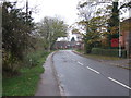
2
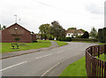
Habblesthorpe Road
Until 1884 Habblesthorpe was a separate parish, but in that year it was merged with North Leverton to form the current parish of North Leverton with Habblesthorpe. The white house is Habblesthorpe Manor http://www.geograph.org.uk/photo/4152689 which dates back to the early 16th century.
Image: © Alan Murray-Rust
Taken: 3 Sep 2014
0.03 miles
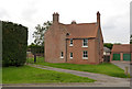
4
Habblesthorpe Manor
Early 17th century house with 19th century additions. The older part of the house is well screened by planting. Listed Grade II.
Image: © Alan Murray-Rust
Taken: 3 Sep 2014
0.05 miles
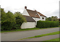
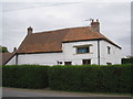
5
Corner Farmhouse, Habblesthorpe
Late 18th century farmhouse with 19th century rear wing, Listed Grade II. The house turns its front away from the main road.
Image: © Alan Murray-Rust
Taken: 3 Sep 2014
0.05 miles
6
Habblesthorpe Manor
A well disguised early seventeenth century house.
Image: © Jonathan Thacker
Taken: 29 Jul 2011
0.06 miles
7
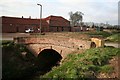
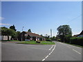
Prebendary Farm
Bridge over Catchwater Drain and Prebendary Farm beyond at Habblesthorpe
Image: © Richard Croft
Taken: 5 Mar 2008
0.07 miles
10
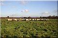
North Leverton sheep
Looking east from the Trent Valley Way long distance footpath
Image: © Richard Croft
Taken: 26 Nov 2006
0.09 miles