IMAGES TAKEN NEAR TO
Gainsborough Road, GAINSBOROUGH, DN21 5HZ
Introduction
This page details the photographs taken nearby to Gainsborough Road, DN21 5HZ by members of the Geograph project.
The Geograph project started in 2005 with the aim of publishing, organising and preserving representative images for every square kilometre of Great Britain, Ireland and the Isle of Man.

There are currently over 7.5m images from over14,400 individuals and you can help contribute to the project by visiting https://www.geograph.org.uk
Image Map
Images are licensed for reuse under creativecommons.org/licenses/by-sa/2.0
Notes
- Clicking on the map will re-center to the selected point.
- The higher the marker number, the further away the image location is from the centre of the postcode.
Image Listing (62 Images Found)
Images are licensed for reuse under creativecommons.org/licenses/by-sa/2.0
Image
Details
Distance


6

Farmhouse at Lea
Note the shaped gable at the right of the picture which raises this quite ordinary farmhouse into something rather more special.
Image: © Jonathan Thacker
Taken: 18 Nov 2011
0.10 miles

9
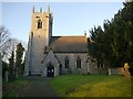
Lea, St. Helen's Church
On the south face of the church tower is a cut bench mark with bolt dating from the primary levelling of a survey line from London to Doncaster in 1848-51. See http://www.geograph.org.uk/photo/5245737 for a close-up and http://www.bench-marks.org.uk/bm30199 for details of the mark.
Image: © Brian Westlake
Taken: 5 Jan 2017
0.12 miles
10

1GL Bolt: Lea, St. Helen's Church
On the south face of the church tower is a cut bench mark with bolt dating from the primary levelling of a survey line from London to Doncaster in 1848-51. See http://www.geograph.org.uk/photo/5245734 for a wider view and http://www.bench-marks.org.uk/bm30199 for details of the mark.
Image: © Brian Westlake
Taken: 5 Jan 2017
0.12 miles