IMAGES TAKEN NEAR TO
South Cliff Road, GAINSBOROUGH, DN21 4GG
Introduction
This page details the photographs taken nearby to South Cliff Road, DN21 4GG by members of the Geograph project.
The Geograph project started in 2005 with the aim of publishing, organising and preserving representative images for every square kilometre of Great Britain, Ireland and the Isle of Man.

There are currently over 7.5m images from over14,400 individuals and you can help contribute to the project by visiting https://www.geograph.org.uk
Image Map
Images are licensed for reuse under creativecommons.org/licenses/by-sa/2.0
Notes
- Clicking on the map will re-center to the selected point.
- The higher the marker number, the further away the image location is from the centre of the postcode.
Image Listing (8 Images Found)
Images are licensed for reuse under creativecommons.org/licenses/by-sa/2.0
Image
Details
Distance
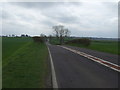
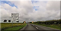
1
Entering West Lindsey
Heading south on the B1398.
Image: © JThomas
Taken: 5 Apr 2014
0.06 miles
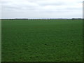
3
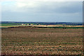
Looking Northwest
Picture taken from a position near the junction of the B1205 and B1398. The white buildings in the distance are Bell Farm and Springfield Farm. In the original photo it is possible to make out the church tower at Scotton which is almost 7km distant.
Image: © David Wright
Taken: 26 Mar 2006
0.11 miles

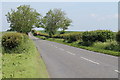
5
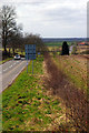
Looking West
Picture taken from the B1205 near to junction with B1398 looking West.
Image: © David Wright
Taken: 26 Mar 2006
0.13 miles