IMAGES TAKEN NEAR TO
Silversides Lane, BRIGG, DN20 9LQ
Introduction
This page details the photographs taken nearby to Silversides Lane, DN20 9LQ by members of the Geograph project.
The Geograph project started in 2005 with the aim of publishing, organising and preserving representative images for every square kilometre of Great Britain, Ireland and the Isle of Man.

There are currently over 7.5m images from over14,400 individuals and you can help contribute to the project by visiting https://www.geograph.org.uk
Image Map (Loading...)


Getting Data...Please wait
Leaflet Map data © OpenStreetMap
Images are licensed for reuse under creativecommons.org/licenses/by-sa/2.0
Notes
- Clicking on the map will re-center to the selected point.
- The higher the marker number, the further away the image location is from the centre of the postcode.
Image Listing (12 Images Found)
Images are licensed for reuse under creativecommons.org/licenses/by-sa/2.0
Image
Details
Distance


5
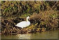
Swan on the Ancholme near Brigg
Solitary bird on a nest on the western bank of the New River Ancholme
Image: © Paul Harrop
Taken: 4 Jan 2017
0.18 miles
6
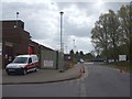
Brigg Leisure Centre undergoing refurbishments
Image: © Glyn Drury
Taken: 2 May 2009
0.18 miles
7

Brigg Leisure Centre
During The floods of 2007
Image: © Ashley Lightfoot
Taken: 25 Jun 2007
0.19 miles

10
The B1206, Scawby Road at Scawby Brook, Brigg
Image: © Ian S
Taken: 2 Apr 2011
0.21 miles