IMAGES TAKEN NEAR TO
Mill Close, BRIGG, DN20 9LL
Introduction
This page details the photographs taken nearby to Mill Close, DN20 9LL by members of the Geograph project.
The Geograph project started in 2005 with the aim of publishing, organising and preserving representative images for every square kilometre of Great Britain, Ireland and the Isle of Man.

There are currently over 7.5m images from over14,400 individuals and you can help contribute to the project by visiting https://www.geograph.org.uk
Image Map (Loading...)


Getting Data...Please wait
Leaflet Map data © OpenStreetMap
Images are licensed for reuse under creativecommons.org/licenses/by-sa/2.0
Notes
- Clicking on the map will re-center to the selected point.
- The higher the marker number, the further away the image location is from the centre of the postcode.
Image Listing (26 Images Found)
Images are licensed for reuse under creativecommons.org/licenses/by-sa/2.0
Image
Details
Distance
1
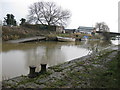
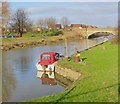
Yarborough Mill Wharf
Just North of Scawby Bridge on the New River Ancolme. The wharf in the foreground used to serve the Yarborough Oil Mills, which ground oilseed into cake. The impressive building had been earmarked for redevelopment, but was demolished after it became derelict following a fire in the 1990's. A new housing estate now stands on the site, however there was no development of the wharf itself.
Image: © Kate Nicol
Taken: 24 Jan 2009
0.06 miles
2

New River Ancholme near Brigg
Looking north.
Image: © JThomas
Taken: 5 Apr 2014
0.06 miles
3
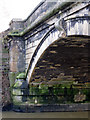
Scawby Bridge
Built 1827 by Sir John Rennie. The bridge is bisected by the 07 easting, but I believe the easternmost pier is in this gridsquare.
Image: © Kate Nicol
Taken: 24 Jan 2009
0.08 miles
5
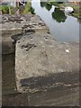
Rivet: Brigg, Ancholme Bridge
A rivet bench mark with damaged arrow cuts on the parapet of the A18 bridge over the River Ancholme. See http://www.geograph.org.uk/photo/4563005 for a wider view and http://www.bench-marks.org.uk/bm68764 for details.
Image: © Brian Westlake
Taken: 1 Jul 2015
0.09 miles
6
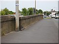
North parapet of the River Ancholme Bridge
The angle to the right of the lamp post carries a rivet bench mark on the top surface. See http://www.geograph.org.uk/photo/4562998 for a close-up and http://www.bench-marks.org.uk/bm68764 for details.
Image: © Brian Westlake
Taken: 1 Jul 2015
0.09 miles
7
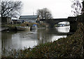
New River Ancholme, Scawby Bridge
There are substantial brick and stone built wharves either side of the river here. To the west of the bridge used to stand Yarborough Oil Mills, which burnt down a number of years ago
Image: © Kate Nicol
Taken: 24 Jan 2009
0.09 miles
8
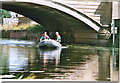
Bridge over the Ancholme: checking for unlicensed eel nets, 2004
Environment Agency staff checking for unlicensed eel nets in the River Ancholme west of Brigg.
Image: © Chris
Taken: Unknown
0.09 miles
9
Brigg - New River Ancholme
Looking north from opposite the Ancholme Leisure Centre, towards the bridge carrying the A18 Scawby Road.
Image: © Paul Harrop
Taken: 4 Jan 2017
0.11 miles
10
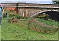
Bridge over the Ancholme: fyke net
The fyke net is being demonstrated on the river bank by Environment Agency staff, who are checking for illegal eel nets in the river.
This is a type of net commonly used for catching eels.
Image: © Chris
Taken: Unknown
0.11 miles