IMAGES TAKEN NEAR TO
Mill Croft, BRIGG, DN20 9EP
Introduction
This page details the photographs taken nearby to Mill Croft, DN20 9EP by members of the Geograph project.
The Geograph project started in 2005 with the aim of publishing, organising and preserving representative images for every square kilometre of Great Britain, Ireland and the Isle of Man.

There are currently over 7.5m images from over14,400 individuals and you can help contribute to the project by visiting https://www.geograph.org.uk
Image Map (37 Images)


Getting Data...Please wait
Leaflet Map data © OpenStreetMap
Images are licensed for reuse under creativecommons.org/licenses/by-sa/2.0
Notes
- Clicking on the map will re-center to the selected point.
- The higher the marker number, the further away the image location is from the centre of the postcode.
Image Listing (37 Images Found)
Images are licensed for reuse under creativecommons.org/licenses/by-sa/2.0
Image
Details
Distance
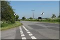
1
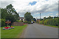
Entering Scawby
Photo taken from Brigg Road. The turning to the left just beyond the "30" sign is Mill Lane.
Image: © David Wright
Taken: 7 Aug 2007
0.12 miles
3
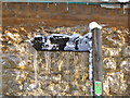
Sign post outside Scawby Forge
Sign post outside Scawby forge - snowy day in 2010
Image: © Elizabeth Thomas
Taken: 7 Feb 2010
0.14 miles
4
Gainsborough Lane from Junction with Mill Road
Image: © J.Hannan-Briggs
Taken: 27 May 2012
0.15 miles
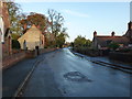
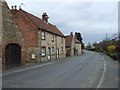
7
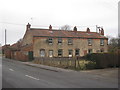
Cottages in Scawby
Situated on West Street.
Image: © Jonathan Thacker
Taken: 23 Jan 2011
0.18 miles
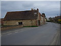
8
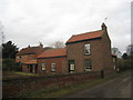
Cottage in Scawby
A humble dwelling close to Scawby Park.
Image: © Jonathan Thacker
Taken: 23 Jan 2011
0.19 miles