IMAGES TAKEN NEAR TO
Hunts Lane, BRIGG, DN20 9EH
Introduction
This page details the photographs taken nearby to Hunts Lane, DN20 9EH by members of the Geograph project.
The Geograph project started in 2005 with the aim of publishing, organising and preserving representative images for every square kilometre of Great Britain, Ireland and the Isle of Man.

There are currently over 7.5m images from over14,400 individuals and you can help contribute to the project by visiting https://www.geograph.org.uk
Image Map (Loading...)


Getting Data...Please wait
Leaflet Map data © OpenStreetMap
Images are licensed for reuse under creativecommons.org/licenses/by-sa/2.0
Notes
- Clicking on the map will re-center to the selected point.
- The higher the marker number, the further away the image location is from the centre of the postcode.
Image Listing (30 Images Found)
Images are licensed for reuse under creativecommons.org/licenses/by-sa/2.0
Image
Details
Distance
1
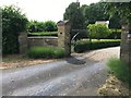
Entrance of the former vicarage in Hibaldstow
There is a cut bench mark on the leftmost gatepost at the entrance to the former vicarage in Hibaldstow. See https://www.geograph.org.uk/photo/6500203 for a closer view and https://www.bench-marks.org.uk/bm123747 for details of the mark.
Image: © Brian Westlake
Taken: 4 Jun 2020
0.07 miles
2
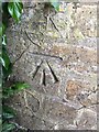
Cut Mark: Hibaldstow, The Vicarage
Cut bench mark on the leftmost gatepost at the entrance to the former vicarage in Hibaldstow. See https://www.geograph.org.uk/photo/6500208 for a wider view and https://www.bench-marks.org.uk/bm123747 for details of the mark.
Image: © Brian Westlake
Taken: 4 Jun 2020
0.07 miles
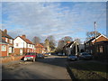
3
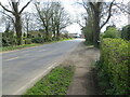
Station Road (B1206), Hibaldstow
Looking southward.
Image: © Peter Wood
Taken: 23 Mar 2024
0.13 miles
6
Church Street Hibaldstow
Looking in the opposite direction to David Wright's view Image
Image: © Jonathan Thacker
Taken: 24 Jan 2011
0.17 miles
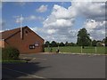
7
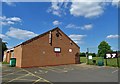
Hibaldstow Village Hall
Next to the village playingfield. It is what you might call a functional building.
Image: © Neil Theasby
Taken: 14 May 2020
0.17 miles
8
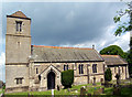
Hibaldstow Church
Church of St. Hibald. The church tower fell down during rebuilding in 1875 and was not replaced until 1958 (hence marked as church without spire or tower on 1940's OS map). The new tower is of concrete blocks to look like ashlar and the effect is, to my eye, rather industrial.
Image: © David Wright
Taken: 7 Jun 2006
0.18 miles
9
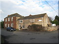
House and barn
Hibaldstow has few attractive or even old buildings. This is one of the few survivors from an earlier age, though greatly altered.
Image: © Jonathan Thacker
Taken: 24 Jan 2011
0.18 miles
10
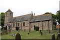
Hibaldstow church
The tower was built in the 1950's
Image: © Julian P Guffogg
Taken: 25 May 2011
0.18 miles