IMAGES TAKEN NEAR TO
West Street, BRIGG, DN20 9AP
Introduction
This page details the photographs taken nearby to West Street, DN20 9AP by members of the Geograph project.
The Geograph project started in 2005 with the aim of publishing, organising and preserving representative images for every square kilometre of Great Britain, Ireland and the Isle of Man.

There are currently over 7.5m images from over14,400 individuals and you can help contribute to the project by visiting https://www.geograph.org.uk
Image Map (Loading...)


Getting Data...Please wait
Leaflet Map data © OpenStreetMap
Images are licensed for reuse under creativecommons.org/licenses/by-sa/2.0
Notes
- Clicking on the map will re-center to the selected point.
- The higher the marker number, the further away the image location is from the centre of the postcode.
Image Listing (13 Images Found)
Images are licensed for reuse under creativecommons.org/licenses/by-sa/2.0
Image
Details
Distance


4

Postbox at Sturton
A George V Postbox in a modern surround.
Image: © Jonathan Thacker
Taken: 23 Jan 2011
0.10 miles
6
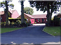
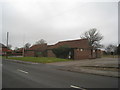
Bungalow on Gainsborough Lane
This bungalow at 28 Gainsborough Lane is typical of recent development in this area.
Image: © David Wright
Taken: 16 Jul 2003
0.14 miles
8
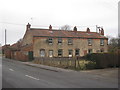
Cottages in Scawby
Situated on West Street.
Image: © Jonathan Thacker
Taken: 23 Jan 2011
0.19 miles
10

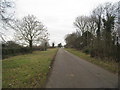
Path to the sewage works
There is an unofficial (but well used) path from Sturton to Scawby sewage works. Its beginning isn't easy to find, but here it is down the sides of the garages off St. Hybald's Grove.
Image: © Jonathan Thacker
Taken: 23 Jan 2011
0.21 miles