IMAGES TAKEN NEAR TO
Station Road, BRIGG, DN20 9AA
Introduction
This page details the photographs taken nearby to Station Road, DN20 9AA by members of the Geograph project.
The Geograph project started in 2005 with the aim of publishing, organising and preserving representative images for every square kilometre of Great Britain, Ireland and the Isle of Man.

There are currently over 7.5m images from over14,400 individuals and you can help contribute to the project by visiting https://www.geograph.org.uk
Image Map (Loading...)


Getting Data...Please wait
Leaflet Map data © OpenStreetMap
Images are licensed for reuse under creativecommons.org/licenses/by-sa/2.0
Notes
- Clicking on the map will re-center to the selected point.
- The higher the marker number, the further away the image location is from the centre of the postcode.
Image Listing (6 Images Found)
Images are licensed for reuse under creativecommons.org/licenses/by-sa/2.0
Image
Details
Distance
3
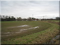
By the junction of B1206 and Brigg Road, Scawby
Standing water in the field and the dyke well filled.
Image: © Jonathan Thacker
Taken: 23 Jan 2011
0.04 miles
4
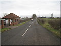
The road to Brigg Power Station
The power station can be seen on the right. Despite its name it is in Scawby parish.
Image: © Jonathan Thacker
Taken: 23 Jan 2011
0.09 miles
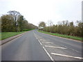
5
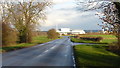
Brigg Road, Scawby
Looking east past the Gainsborough Road turn with Brigg power station in the distance.
Image: © Jonathan Billinger
Taken: 25 Nov 2018
0.15 miles
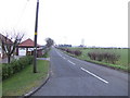
6
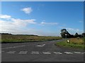
Gainsborough Lane junction from Brigg Road, Scawby
Image: © Steve Fareham
Taken: 3 Aug 2013
0.22 miles