IMAGES TAKEN NEAR TO
Western Avenue, BRIGG, DN20 8PY
Introduction
This page details the photographs taken nearby to Western Avenue, DN20 8PY by members of the Geograph project.
The Geograph project started in 2005 with the aim of publishing, organising and preserving representative images for every square kilometre of Great Britain, Ireland and the Isle of Man.

There are currently over 7.5m images from over14,400 individuals and you can help contribute to the project by visiting https://www.geograph.org.uk
Image Map (12 Images)


Getting Data...Please wait
Leaflet Map data © OpenStreetMap
Images are licensed for reuse under creativecommons.org/licenses/by-sa/2.0
Notes
- Clicking on the map will re-center to the selected point.
- The higher the marker number, the further away the image location is from the centre of the postcode.
Image Listing (12 Images Found)
Images are licensed for reuse under creativecommons.org/licenses/by-sa/2.0
Image
Details
Distance
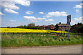
1
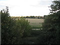
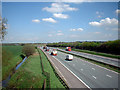
Brigg fringes
Seen from the bridge over the M180.
Image: © Jonathan Thacker
Taken: 18 Sep 2011
0.08 miles
2
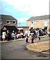
1977 Street Party at Horstead Avenue, Brigg
Street party held at Horstead Avenue in Brigg. The occasion was the silver jubilee for Queen Elizabeth 2nd. Image shows stalls at the pedestrianized area at the end of the avenue; some houses were adorned with bunting.
Image: © Clint Mann
Taken: Unknown
0.12 miles
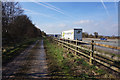
5
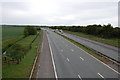
M180
Picture taken looking approx. northeast from the bridge carrying the road to Low Farm over the motorway. The ditch to the left is the Catchwater Drain.
Image: © David Wright
Taken: 5 May 2006
0.16 miles
8
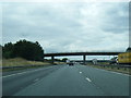
M180 nears Grammar School Lane overbridge
Image: © Colin Pyle
Taken: 6 Aug 2013
0.20 miles
9
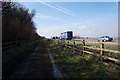
The Northern Edge of Brigg
This picture was taken from a position close to the bridge carrying the unclassified road to Low Farm over the M180. The houses on the right hand side of the photo are the currently the northerly limit of the built-up area of Brigg. The Motorway is immediately on the left of the field and prevents further urban expansion in that direction.
Image: © David Wright
Taken: 5 May 2006
0.22 miles
