IMAGES TAKEN NEAR TO
Rue De Nozay, BRIGG, DN20 0TZ
Introduction
This page details the photographs taken nearby to Rue De Nozay, DN20 0TZ by members of the Geograph project.
The Geograph project started in 2005 with the aim of publishing, organising and preserving representative images for every square kilometre of Great Britain, Ireland and the Isle of Man.

There are currently over 7.5m images from over14,400 individuals and you can help contribute to the project by visiting https://www.geograph.org.uk
Image Map (Loading...)


Getting Data...Please wait
Leaflet Map data © OpenStreetMap
Images are licensed for reuse under creativecommons.org/licenses/by-sa/2.0
Notes
- Clicking on the map will re-center to the selected point.
- The higher the marker number, the further away the image location is from the centre of the postcode.
Image Listing (6 Images Found)
Images are licensed for reuse under creativecommons.org/licenses/by-sa/2.0
Image
Details
Distance
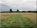
1
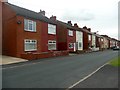
Footpath to Broughton
The houses on Avenue Nozay can be seen ahead,
Image: © Jonathan Thacker
Taken: 2 Sep 2015
0.07 miles
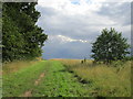
3
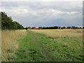
Unofficial path north of Broughton
Appears to lead to Ermine Street. The land here appears to have been abandoned by agriculture.
Image: © Jonathan Thacker
Taken: 2 Sep 2015
0.19 miles
4
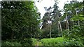
The edge of East Wood
All the land immediately north of Broughton that isn't woodland has been abandoned and allowed to revert eventually to woodland.
Image: © Jonathan Thacker
Taken: 2 Sep 2015
0.22 miles