IMAGES TAKEN NEAR TO
Ermine Street, BRIGG, DN20 0DQ
Introduction
This page details the photographs taken nearby to Ermine Street, DN20 0DQ by members of the Geograph project.
The Geograph project started in 2005 with the aim of publishing, organising and preserving representative images for every square kilometre of Great Britain, Ireland and the Isle of Man.

There are currently over 7.5m images from over14,400 individuals and you can help contribute to the project by visiting https://www.geograph.org.uk
Image Map
Images are licensed for reuse under creativecommons.org/licenses/by-sa/2.0
Notes
- Clicking on the map will re-center to the selected point.
- The higher the marker number, the further away the image location is from the centre of the postcode.
Image Listing (79 Images Found)
Images are licensed for reuse under creativecommons.org/licenses/by-sa/2.0
Image
Details
Distance
1
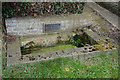
Water trough on Appleby Lane, Broughton
http://www.geograph.org.uk/photo/4877442
Image: © Ian S
Taken: 21 Mar 2016
0.02 miles
2
Water trough on Appleby Lane, Broughton
http://www.geograph.org.uk/photo/4877441
Image: © Ian S
Taken: 21 Mar 2016
0.03 miles
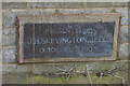
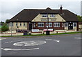
7
Dog & Rat Public House, Broughton
http://www.geograph.org.uk/photo/4877037 http://www.geograph.org.uk/photo/4877440
Image: © Ian S
Taken: 21 Mar 2016
0.04 miles
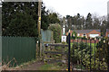
8
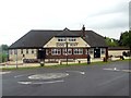
The Dog and Rat Tavern
An unusually named pub at a mini-roundabout junction
Image: © Graham Hogg
Taken: 28 Jun 2016
0.04 miles
10
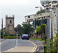
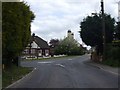
St Mary's church in Broughton
Looking east along the High Street.
Image: © Mat Fascione
Taken: 28 Aug 2016
0.04 miles