IMAGES TAKEN NEAR TO
Westminster Road, BRIGG, DN20 0AZ
Introduction
This page details the photographs taken nearby to Westminster Road, DN20 0AZ by members of the Geograph project.
The Geograph project started in 2005 with the aim of publishing, organising and preserving representative images for every square kilometre of Great Britain, Ireland and the Isle of Man.

There are currently over 7.5m images from over14,400 individuals and you can help contribute to the project by visiting https://www.geograph.org.uk
Image Map (Loading...)


Getting Data...Please wait
Leaflet Map data © OpenStreetMap
Images are licensed for reuse under creativecommons.org/licenses/by-sa/2.0
Notes
- Clicking on the map will re-center to the selected point.
- The higher the marker number, the further away the image location is from the centre of the postcode.
Image Listing (29 Images Found)
Images are licensed for reuse under creativecommons.org/licenses/by-sa/2.0
Image
Details
Distance
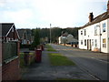
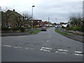
3
Westwood, Broughton
Taken from the Opencast Way.
Image: © Ian S
Taken: 21 Mar 2016
0.05 miles
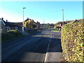
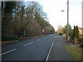
4
Westminster Road, Broughton
West off Appleby Lane.
Image: © JThomas
Taken: 5 Apr 2014
0.06 miles
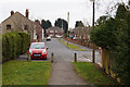
6
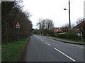
Appleby Lane (B1207)
Heading north out of Broughton.
The old Ermine Street Roman Road.
Image: © JThomas
Taken: 5 Apr 2014
0.07 miles
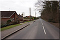
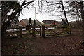
9
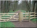
Woodland path
Access to West Wood off Appleby Lane (The old Ermine Street Roman Road).
Image: © JThomas
Taken: 5 Apr 2014
0.08 miles