IMAGES TAKEN NEAR TO
Hungate, BARTON-UPON-HUMBER, DN18 5PN
Introduction
This page details the photographs taken nearby to Hungate, DN18 5PN by members of the Geograph project.
The Geograph project started in 2005 with the aim of publishing, organising and preserving representative images for every square kilometre of Great Britain, Ireland and the Isle of Man.

There are currently over 7.5m images from over14,400 individuals and you can help contribute to the project by visiting https://www.geograph.org.uk
Image Map
Images are licensed for reuse under creativecommons.org/licenses/by-sa/2.0
Notes
- Clicking on the map will re-center to the selected point.
- The higher the marker number, the further away the image location is from the centre of the postcode.
Image Listing (856 Images Found)
Images are licensed for reuse under creativecommons.org/licenses/by-sa/2.0
Image
Details
Distance
1
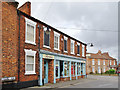
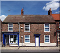
Chapel Lane, Barton-upon-Humber, Lincolnshire
Nos.5 & 7 Chapel Lane, dwellings, late 18th or early 19th century, now with modern shop front. Occupied by Barton Shopping Centre, opened 1988. Grade II Listed Building https://www.historicengland.org.uk/listing/the-list/list-entry/1083114
Image: © Bernard Sharp
Taken: 20 Apr 2017
0.01 miles
2
Chapel Lane, Barton-upon-Humber, Lincolnshire
From left: No.3 Chapel Lane, house, 18th century. Grade II Listed Building https://www.historicengland.org.uk/listing/the-list/list-entry/1051615
Nos.5 & 7 Chapel Lane, house, late 18th or early 19th century, now with modern shop front.
Grade II Listed Building https://www.historicengland.org.uk/listing/the-list/list-entry/1083114
Image: © Bernard Sharp
Taken: 20 Apr 2017
0.01 miles
3
Partners Tea Room
Partners Tea Room, High Street, Barton Upon Humber.
Image: © David Wright
Taken: 6 Jun 2007
0.01 miles
4
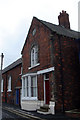
77 High Street
Grade II listed early 19th century house in Junction Square at the junction of Hungate and High Street.
Image: © Richard Croft
Taken: 27 Sep 2022
0.01 miles
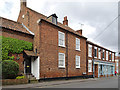
5
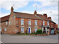
High Street, Barton-upon-Humber, Lincolnshire
At the junction with Hungate, No.77 High Street, a late Georgian farmhouse. The frontage was raised in the later 19th century - see the difference in the roof-line, and the thicker, redder bricks under the front eaves. The moulded window lintels with keystones bearing the bearded face of Pan were part of the same face-lift.
Grade II Listed Building https://www.historicengland.org.uk/listing/the-list/list-entry/1346786
Image: © Bernard Sharp
Taken: 13 Apr 2017
0.01 miles
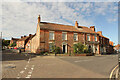
6
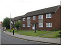
Hungate, Barton Upon Humber
Local Authority built housing on Hungate.
Image: © David Wright
Taken: 4 Jun 2009
0.01 miles
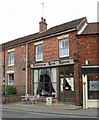
7
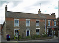
77 Hungate, Barton Upon Humber
Grade II listed building "Early C19 house, refronted mid C19. 2 storeys in painted brick with pantile roof.3 windows, no glazing bars, carved rusticated lintels with mask keystones. 2 windows to ground floor. Pedimented doorcase with narrow pilasters and door of 6 panels, 2 glazed." http://www.britishlistedbuildings.co.uk/en-165604-77-barton-upon-humber
Image: © David Wright
Taken: 3 Jul 2010
0.02 miles
8
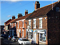
Western end of High Street
This is the western end of Barton-Upon-Humber High Street, close to the junction with Fleetgate.
Image: © David Wright
Taken: 1 Nov 2005
0.02 miles
9
Barton Veterinary Centre
Barton Veterinary Centre, High Street, Barton-Upon-Humber.
Image: © David Wright
Taken: 14 Jul 2006
0.02 miles
10
The Old School House
The Old School House, Maltby Lane. The school is now a Youth Centre run by the North Lincolnshire Directorate of Education & Personal Development.
Image: © David Wright
Taken: 22 Sep 2006
0.02 miles