IMAGES TAKEN NEAR TO
Maltkiln Road, BARTON-UPON-HUMBER, DN18 5JR
Introduction
This page details the photographs taken nearby to Maltkiln Road, DN18 5JR by members of the Geograph project.
The Geograph project started in 2005 with the aim of publishing, organising and preserving representative images for every square kilometre of Great Britain, Ireland and the Isle of Man.

There are currently over 7.5m images from over14,400 individuals and you can help contribute to the project by visiting https://www.geograph.org.uk
Image Map
Images are licensed for reuse under creativecommons.org/licenses/by-sa/2.0
Notes
- Clicking on the map will re-center to the selected point.
- The higher the marker number, the further away the image location is from the centre of the postcode.
Image Listing (448 Images Found)
Images are licensed for reuse under creativecommons.org/licenses/by-sa/2.0
Image
Details
Distance
1
Humber Bank Footpath
Photo taken looking towards Hull.
Image: © David Wright
Taken: 17 Nov 2008
0.01 miles
3
Humber
Foreshore viewing area at Barton Waterside.
Image: © David Wright
Taken: 2 Jan 2008
0.01 miles
4
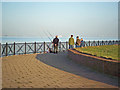
Humber Bank Footpath
Party of Anglers on the Humber bank footpath.
Image: © David Wright
Taken: 28 Nov 2009
0.01 miles
5
Humber Bridge View Point
No viewers today!
Image: © David Wright
Taken: 11 Jan 2008
0.02 miles
6
Waters' Edge Visitor Centre
Photo taken from the end of the footbridge over Barton Haven.
Image: © David Wright
Taken: 10 Dec 2008
0.02 miles
7
Waters' Edge Visitor Centre, Barton
North Lincolnshire Council facility http://www.visitnorthlincolnshire.com/item/waters-edge-country-park-visitor-centre/ dating from 2006, for visitors to the surrounding country park, which is based around the network of flooded pits from which clay was once extracted for the area's extensive brick and tile making industry https://www.northlincs.gov.uk/tourism-museums-the-arts/waters-edge-visitor-centre-and-country-park/waters-edge-visitor-information/history-of-waters-edge/. Seen from the boardwalk across the most north-westerly of the ponds.
Image: © Paul Harrop
Taken: 14 Apr 2020
0.02 miles
8
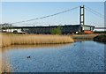
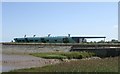
Waters' Edge Park, Barton-Upon-Humber
Waters' Edge Country Park covers 86 acres of the south bank of the River Humber. This shows the visitor centre from the Humber Bridge.
Image: © Pauline E
Taken: 14 Sep 2012
0.02 miles
10
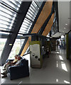
Waters' Edge Visitor Centre
Interior of the Waters' Edge visitor centre Image
Image: © David Wright
Taken: 5 Jul 2011
0.02 miles