IMAGES TAKEN NEAR TO
Waterside Road, BARTON-UPON-HUMBER, DN18 5BG
Introduction
This page details the photographs taken nearby to Waterside Road, DN18 5BG by members of the Geograph project.
The Geograph project started in 2005 with the aim of publishing, organising and preserving representative images for every square kilometre of Great Britain, Ireland and the Isle of Man.

There are currently over 7.5m images from over14,400 individuals and you can help contribute to the project by visiting https://www.geograph.org.uk
Image Map (Loading...)


Getting Data...Please wait
Leaflet Map data © OpenStreetMap
Images are licensed for reuse under creativecommons.org/licenses/by-sa/2.0
Notes
- Clicking on the map will re-center to the selected point.
- The higher the marker number, the further away the image location is from the centre of the postcode.
Image Listing (270 Images Found)
Images are licensed for reuse under creativecommons.org/licenses/by-sa/2.0
Image
Details
Distance

3
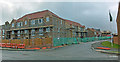
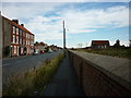
New Development off Waterside Road
This land is very low-lying and is coloured a nice shade of blue on the Environment Agency flood map (Flooding from rivers or sea without defences). Fortunately the flood wall along the nearby Haven has recently been improved.
Image: © David Wright
Taken: 15 Jan 2008
0.01 miles
4
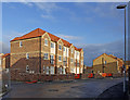
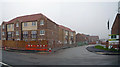
New Houses on St. Chad's Way
The current bleak economic climate has halted work on this new estate and none of the houses appear to have been sold.
Image: © David Wright
Taken: 10 Dec 2008
0.03 miles
5
Maltkiln Road, Barton-upon-Humber, Lincolnshire
An integral part of the Ropewalk is a sculpture garden, located immediately north of the building and accessed via the visitors' entrance. Looking south towards the former Ropery despatch building.
Image: © Bernard Sharp
Taken: 2 May 2017
0.03 miles
6
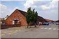
The Ropewalk
When the ropemaking industry of Barton-Upon-Humber declined this building was converted to an Arts centre.
Image: © David Wright
Taken: 29 Jul 2006
0.03 miles
7
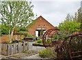
Maltkiln Road, Barton-upon-Humber, Lincolnshire
An integral part of the Ropewalk is a sculpture garden, located immediately north of the building and accessed via the visitors' entrance.
Image: © Bernard Sharp
Taken: 2 May 2017
0.03 miles
8
New Development off Waterside Road
This new Kier development is on land which is very low-lying and coloured a nice shade of blue on the Environment Agency flood map (Flooding from rivers or sea without defences). Fortunately the flood wall along the nearby Haven has recently been improved.
Image: © David Wright
Taken: 15 Mar 2008
0.04 miles
9
A walk to Winteringham #2
Waterside road, Barton upon Humber.
Image: © Ian S
Taken: 12 Aug 2010
0.04 miles
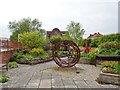
10

Sculpture outside the Ropery
Former rope works at Barton on Humber.
Image: © Steve Fareham
Taken: 15 Nov 2015
0.04 miles