IMAGES TAKEN NEAR TO
Orchard Close, SCUNTHORPE, DN17 3UT
Introduction
This page details the photographs taken nearby to Orchard Close, DN17 3UT by members of the Geograph project.
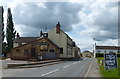
The Geograph project started in 2005 with the aim of publishing, organising and preserving representative images for every square kilometre of Great Britain, Ireland and the Isle of Man.

There are currently over 7.5m images from over14,400 individuals and you can help contribute to the project by visiting https://www.geograph.org.uk
Image Map (Loading...)


Getting Data...Please wait
Leaflet Map data © OpenStreetMap
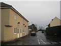
Images are licensed for reuse under creativecommons.org/licenses/by-sa/2.0
Notes
- Clicking on the map will re-center to the selected point.
- The higher the marker number, the further away the image location is from the centre of the postcode.
Image Listing (29 Images Found)
Images are licensed for reuse under creativecommons.org/licenses/by-sa/2.0
Image
Details
Distance
1
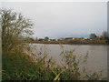
The River Trent and Burringham seen from Althorpe
Image: © Jonathan Thacker
Taken: 21 Nov 2010
0.08 miles
2
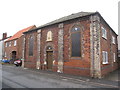
Former Wesley Chapel, Burringham
Built in 1863. Burringham boasted two chapels and a parish church, but all three are now closed.
Image: © Jonathan Thacker
Taken: 27 Oct 2011
0.08 miles
3
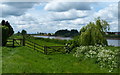
River Trent flood defences at Burringham
Image: © Mat Fascione
Taken: 21 May 2017
0.10 miles
4
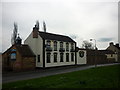
Take A Gander Bar & Restaurant, East Butterwick
Image: © Ian S
Taken: 2 Apr 2011
0.10 miles
5
Take a Gander Bar & Restaurant
Along Station Road in Burringham, on the east bank of the River Trent.
Image: © Mat Fascione
Taken: 21 May 2017
0.10 miles
6
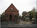
Temperance Hall, Burringham, North Lincolnshire
This Photo shows The Temperance Hall. Burringham also boasted two chapels and a parish church, but sadly The Primitive Methodist chapel was demolished. The Wesleyan chapel has been converted into a residential property. and St Johns church is now closed.
Image: © Jonathan Thacker
Taken: 27 Oct 2011
0.15 miles
7
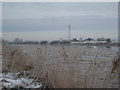
Ice on the Trent at Althorpe
Prolonged cold weather has brought ice even to the Lower Trent which is generally warmed by discharges from power stations upstream.
Image: © Jonathan Thacker
Taken: 26 Dec 2010
0.15 miles
8
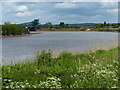
The River Trent at Burringham
In the distance is the King George V Bridge at Gunness.
Image: © Mat Fascione
Taken: 21 May 2017
0.17 miles
9
Ferry Road, Althorpe
A reminder that before the opening of Keadby Bridge a ferry ran between Althorpe and Burringham.
Image: © Jonathan Thacker
Taken: 21 Nov 2010
0.19 miles
10
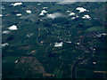
The River Trent from the air
Althorpe can be seen on the west bank of the river.
Image: © Thomas Nugent
Taken: 13 Jun 2014
0.20 miles