IMAGES TAKEN NEAR TO
West Butterwick, SCUNTHORPE, DN17 3LJ
Introduction
This page details the photographs taken nearby to DN17 3LJ by members of the Geograph project.
The Geograph project started in 2005 with the aim of publishing, organising and preserving representative images for every square kilometre of Great Britain, Ireland and the Isle of Man.

There are currently over 7.5m images from over14,400 individuals and you can help contribute to the project by visiting https://www.geograph.org.uk
Image Map (3 Images)


Getting Data...Please wait
Leaflet Map data © OpenStreetMap
Images are licensed for reuse under creativecommons.org/licenses/by-sa/2.0
Notes
- Clicking on the map will re-center to the selected point.
- The higher the marker number, the further away the image location is from the centre of the postcode.
Image Listing (3 Images Found)
Images are licensed for reuse under creativecommons.org/licenses/by-sa/2.0
Image
Details
Distance
1
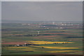
North Lincs wind turbine dominated landscape
The latest addition seems to be this 100ft turbine in the foreground, at a Farm marked "Common Farm" on the map, but the application states "Butterwick Grange Farm, West Butterwick".
Behind it is the turbine by the M180 bridge (Image), and behind that the windfarm next to Normanby Hall Country Park (Image).
Just off shot to the right are turbines at two more locations just south of Scunthorpe, and to the left a big windfarm near Goole.
Image: © Chris
Taken: 5 May 2013
0.04 miles