IMAGES TAKEN NEAR TO
South Street, SCUNTHORPE, DN17 3JY
Introduction
This page details the photographs taken nearby to South Street, DN17 3JY by members of the Geograph project.
The Geograph project started in 2005 with the aim of publishing, organising and preserving representative images for every square kilometre of Great Britain, Ireland and the Isle of Man.

There are currently over 7.5m images from over14,400 individuals and you can help contribute to the project by visiting https://www.geograph.org.uk
Image Map (Loading...)


Getting Data...Please wait
Leaflet Map data © OpenStreetMap
Images are licensed for reuse under creativecommons.org/licenses/by-sa/2.0
Notes
- Clicking on the map will re-center to the selected point.
- The higher the marker number, the further away the image location is from the centre of the postcode.
Image Listing (47 Images Found)
Images are licensed for reuse under creativecommons.org/licenses/by-sa/2.0
Image
Details
Distance
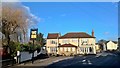
2
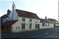
The Ferry Boat Inn
Though it is many years since a ferry linked West & East Butterwick
Image: © Graham Hogg
Taken: 8 Dec 2015
0.02 miles
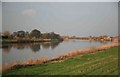
3
The River Trent embankment West Butterwick
The light coloured building in the background is the Ferryboat Inn.
Image: © Steve Fareham
Taken: 2 Mar 2008
0.04 miles
5
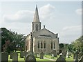
St Mary the Virgin, West Butterwick
Situated on the west bank of the River Trent, the Gothic church is of 1841 by Charles Briggs.
Image: © Dave Hitchborne
Taken: 23 Jun 2004
0.06 miles
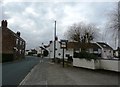
7
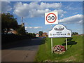
Approaching West Butterwick
The Shell Guide to Lincolnshire says of West Butterwick:- "A large Dutch-like village on the west bank of the Trent, looking across to East Butterwick village opposite." Most of the settlements on the west bank of the Trent have their counterparts on the east side, and numerous ferries plied between the two sides in former times. This is just now remembered in the various names involving 'ferry'. A close up of the attractive sign can be seen at https://www.geograph.org.uk/photo/6267474
Image: © Marathon
Taken: 8 Sep 2019
0.07 miles
8
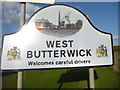
The village sign for West Butterwick
The Shell Guide to Lincolnshire says of West Butterwick:- "A large Dutch-like village on the west bank of the Trent, looking across to East Butterwick village opposite." Most of the settlements on the west bank of the Trent have their counterparts on the east side, and numerous ferries plied between the two sides in former times. This is just now remembered in the various names involving 'ferry'.
The context of the attractive sign can be seen at https://www.geograph.org.uk/photo/6267470
Image: © Marathon
Taken: 8 Sep 2019
0.07 miles
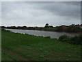
10
The River Trent
Taken from the river bank at East Butterwick looking north
Image: © roger geach
Taken: 26 Jan 2010
0.08 miles