IMAGES TAKEN NEAR TO
Chapel Lane, SCUNTHORPE, DN17 3EN
Introduction
This page details the photographs taken nearby to Chapel Lane, DN17 3EN by members of the Geograph project.
The Geograph project started in 2005 with the aim of publishing, organising and preserving representative images for every square kilometre of Great Britain, Ireland and the Isle of Man.

There are currently over 7.5m images from over14,400 individuals and you can help contribute to the project by visiting https://www.geograph.org.uk
Image Map
Images are licensed for reuse under creativecommons.org/licenses/by-sa/2.0
Notes
- Clicking on the map will re-center to the selected point.
- The higher the marker number, the further away the image location is from the centre of the postcode.
Image Listing (54 Images Found)
Images are licensed for reuse under creativecommons.org/licenses/by-sa/2.0
Image
Details
Distance
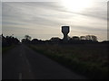
4
Chapel lane junction with B3192 at Keadby
Image: © John Firth
Taken: 10 Jun 2013
0.09 miles
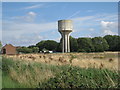
5

Keadby across the Trent
Water tower and power station prominent.
Image: © Jonathan Thacker
Taken: 13 Mar 2017
0.10 miles
7
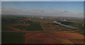
Looking across the M180 and up the River Trent to Keadby and Gunness: aerial 2015
Not to mention the inevitable accompaniment of windfarms.
Image: © Chris
Taken: 5 Apr 2015
0.11 miles
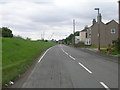
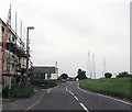
8
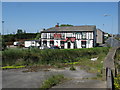
Keadby The Auld South Yorkshire Public House
Image: © Gordon Kneale Brooke
Taken: 31 May 2009
0.11 miles
9
Former Chapel, Keadby
The inscription reads "Wesleyan Chapel 1861".
Image: © Jonathan Thacker
Taken: 11 Aug 2010
0.11 miles
10
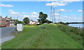
River Trent floodbank at Keadby
The River Trent is the third-longest river in the United Kingdom, it is 298 kilometres (185 miles) in length. It rises at Biddulph Moor in Staffordshire. Its mouth is where it joins the Humber Estuary at Trent Falls, on the Lincolnshire and East Yorkshire county boundary.
Image: © Mat Fascione
Taken: 29 Aug 2016
0.12 miles