IMAGES TAKEN NEAR TO
Carr Dyke Road, SCUNTHORPE, DN17 3AB
Introduction
This page details the photographs taken nearby to Carr Dyke Road, DN17 3AB by members of the Geograph project.
The Geograph project started in 2005 with the aim of publishing, organising and preserving representative images for every square kilometre of Great Britain, Ireland and the Isle of Man.

There are currently over 7.5m images from over14,400 individuals and you can help contribute to the project by visiting https://www.geograph.org.uk
Image Map (Loading...)


Getting Data...Please wait
Leaflet Map data © OpenStreetMap
Images are licensed for reuse under creativecommons.org/licenses/by-sa/2.0
Notes
- Clicking on the map will re-center to the selected point.
- The higher the marker number, the further away the image location is from the centre of the postcode.
Image Listing (13 Images Found)
Images are licensed for reuse under creativecommons.org/licenses/by-sa/2.0
Image
Details
Distance
2
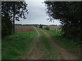
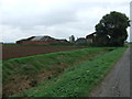
Farm track near Burringham South Grange
Looking east.
Image: © JThomas
Taken: 20 Sep 2014
0.03 miles
3
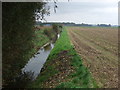
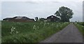
Warping Drain
Looking east near Burringham South Grange.
Image: © JThomas
Taken: 20 Sep 2014
0.04 miles
4
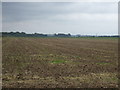
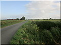
Farmland east of Carr Dyke Road
Near Burringham South Grange.
Image: © JThomas
Taken: 20 Sep 2014
0.06 miles
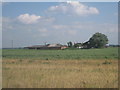
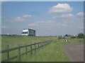
7
Wheat field and Carr Dyke Road
Burringham South Grange on the left in the distance.
Image: © Jonathan Thacker
Taken: 1 Jul 2023
0.12 miles
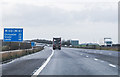
9
Traffic on M180 seen from Carr Dyke Road
Image: © Jonathan Thacker
Taken: 11 Jun 2010
0.19 miles
10
M180, 20 Miles to Doncaster
Approaching the River Trent crossing, at Marker 18.0
Image: © J.Hannan-Briggs
Taken: 26 Dec 2015
0.21 miles