IMAGES TAKEN NEAR TO
Carr Dyke Road, SCUNTHORPE, DN17 3AA
Introduction
This page details the photographs taken nearby to Carr Dyke Road, DN17 3AA by members of the Geograph project.
The Geograph project started in 2005 with the aim of publishing, organising and preserving representative images for every square kilometre of Great Britain, Ireland and the Isle of Man.

There are currently over 7.5m images from over14,400 individuals and you can help contribute to the project by visiting https://www.geograph.org.uk
Image Map (2 Images)


Getting Data...Please wait
Leaflet Map data © OpenStreetMap
Images are licensed for reuse under creativecommons.org/licenses/by-sa/2.0
Notes
- Clicking on the map will re-center to the selected point.
- The higher the marker number, the further away the image location is from the centre of the postcode.
Image Listing (2 Images Found)
Images are licensed for reuse under creativecommons.org/licenses/by-sa/2.0
Image
Details
Distance
1
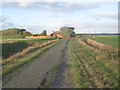
Carr Dyke Road
This section of Carr Dyke Road is little used and slowly collapsing into the drains on either side.
Image: © Jonathan Thacker
Taken: 23 Oct 2013
0.02 miles
2
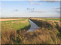
Healey's Drain
The escarpment and the southern part of Scunthorpe can be seen in the distance.
Image: © Jonathan Thacker
Taken: 23 Oct 2013
0.21 miles