IMAGES TAKEN NEAR TO
Somerby Road, SCUNTHORPE, DN17 2EX
Introduction
This page details the photographs taken nearby to Somerby Road, DN17 2EX by members of the Geograph project.
The Geograph project started in 2005 with the aim of publishing, organising and preserving representative images for every square kilometre of Great Britain, Ireland and the Isle of Man.

There are currently over 7.5m images from over14,400 individuals and you can help contribute to the project by visiting https://www.geograph.org.uk
Image Map
Images are licensed for reuse under creativecommons.org/licenses/by-sa/2.0
Notes
- Clicking on the map will re-center to the selected point.
- The higher the marker number, the further away the image location is from the centre of the postcode.
Image Listing (14 Images Found)
Images are licensed for reuse under creativecommons.org/licenses/by-sa/2.0
Image
Details
Distance
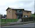
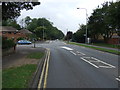
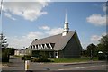
6
Church of Jesus Christ and Latter Day Saints
Image: © JThomas
Taken: 20 Sep 2014
0.12 miles
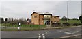
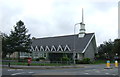
7
Church of Jesus Christ of Latter Day Saints
Image: © Graham Hogg
Taken: 23 Oct 2018
0.12 miles
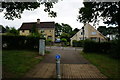
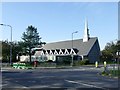
8
Church of Jesus Christ of Latter Day Saints
Image: © Chris Morgan
Taken: 5 Feb 2020
0.12 miles
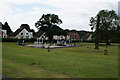
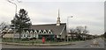
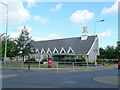
9
Church of Jesus Christ and Latter Day Saints
Immaculately kept modern church with an enthusiastic congregation
Image: © Richard Croft
Taken: 5 Jun 2006
0.12 miles
10
Church of Jesus Christ of Latter Day Saints
Mormon church on Burringham Road, South Scunthorpe.
Image: © Jonathan Billinger
Taken: 27 May 2010
0.13 miles