IMAGES TAKEN NEAR TO
Peacock Street, SCUNTHORPE, DN17 2DX
Introduction
This page details the photographs taken nearby to Peacock Street, DN17 2DX by members of the Geograph project.
The Geograph project started in 2005 with the aim of publishing, organising and preserving representative images for every square kilometre of Great Britain, Ireland and the Isle of Man.

There are currently over 7.5m images from over14,400 individuals and you can help contribute to the project by visiting https://www.geograph.org.uk
Image Map (Loading...)


Getting Data...Please wait
Leaflet Map data © OpenStreetMap
Images are licensed for reuse under creativecommons.org/licenses/by-sa/2.0
Notes
- Clicking on the map will re-center to the selected point.
- The higher the marker number, the further away the image location is from the centre of the postcode.
Image Listing (21 Images Found)
Images are licensed for reuse under creativecommons.org/licenses/by-sa/2.0
Image
Details
Distance
4
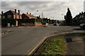
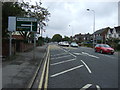
Rochdale Road / A169 Junction
Looking east along Rochdale Road.
Image: © Peter Church
Taken: 26 Feb 2008
0.16 miles
7
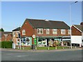
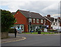
Local pet and garden supplies store
On the corner of Burringham Road and Priory Road
Image: © Graham Hogg
Taken: 23 Oct 2018
0.19 miles
9
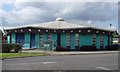
Ashby Turn Children's Centre, Scunthorpe
Flying saucer-inspired building for pre-school infants.
Image: © Paul Harrop
Taken: 19 May 2008
0.20 miles