IMAGES TAKEN NEAR TO
Plymouth Road, SCUNTHORPE, DN17 1TT
Introduction
This page details the photographs taken nearby to Plymouth Road, DN17 1TT by members of the Geograph project.
The Geograph project started in 2005 with the aim of publishing, organising and preserving representative images for every square kilometre of Great Britain, Ireland and the Isle of Man.

There are currently over 7.5m images from over14,400 individuals and you can help contribute to the project by visiting https://www.geograph.org.uk
Image Map (Loading...)


Getting Data...Please wait
Leaflet Map data © OpenStreetMap
Images are licensed for reuse under creativecommons.org/licenses/by-sa/2.0
Notes
- Clicking on the map will re-center to the selected point.
- The higher the marker number, the further away the image location is from the centre of the postcode.
Image Listing (12 Images Found)
Images are licensed for reuse under creativecommons.org/licenses/by-sa/2.0
Image
Details
Distance
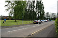
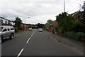
3
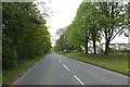
Scotter Road
Looking along a very quiet Scotter Road which was closed for the North Lincolnshire Half Marathon.
Image: © DS Pugh
Taken: 7 May 2017
0.11 miles
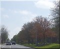
5
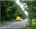
Scotter Road, Scunthorpe
This stretch of the road known locally as "Scotter Bottom", presumably because it is at the bottom of the ridge upon which most of the town is built.
Image: © Paul Harrop
Taken: 26 Jun 2008
0.13 miles