IMAGES TAKEN NEAR TO
Quantock Close, SCUNTHORPE, DN17 1TP
Introduction
This page details the photographs taken nearby to Quantock Close, DN17 1TP by members of the Geograph project.
The Geograph project started in 2005 with the aim of publishing, organising and preserving representative images for every square kilometre of Great Britain, Ireland and the Isle of Man.

There are currently over 7.5m images from over14,400 individuals and you can help contribute to the project by visiting https://www.geograph.org.uk
Image Map
Images are licensed for reuse under creativecommons.org/licenses/by-sa/2.0
Notes
- Clicking on the map will re-center to the selected point.
- The higher the marker number, the further away the image location is from the centre of the postcode.
Image Listing (26 Images Found)
Images are licensed for reuse under creativecommons.org/licenses/by-sa/2.0
Image
Details
Distance
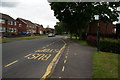
7
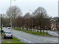
West Common Lane
Looking west from the junction with Herrick Road
Image: © Graham Hogg
Taken: 23 Jan 2018
0.18 miles
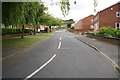
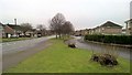
9
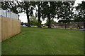
Grassed area off West Common Lane, Scunthorpe
Image: © Ian S
Taken: 11 Jun 2014
0.19 miles
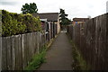
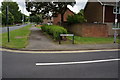
10
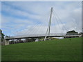
Bridge over West Common Lane
Carries a cyclepath which runs along the ridge from the north to south in Scunthorpe.
Image: © Jonathan Thacker
Taken: 13 Oct 2012
0.19 miles